N23A Red Feather Lakes, CO, USA - Earthquake Result Viewer
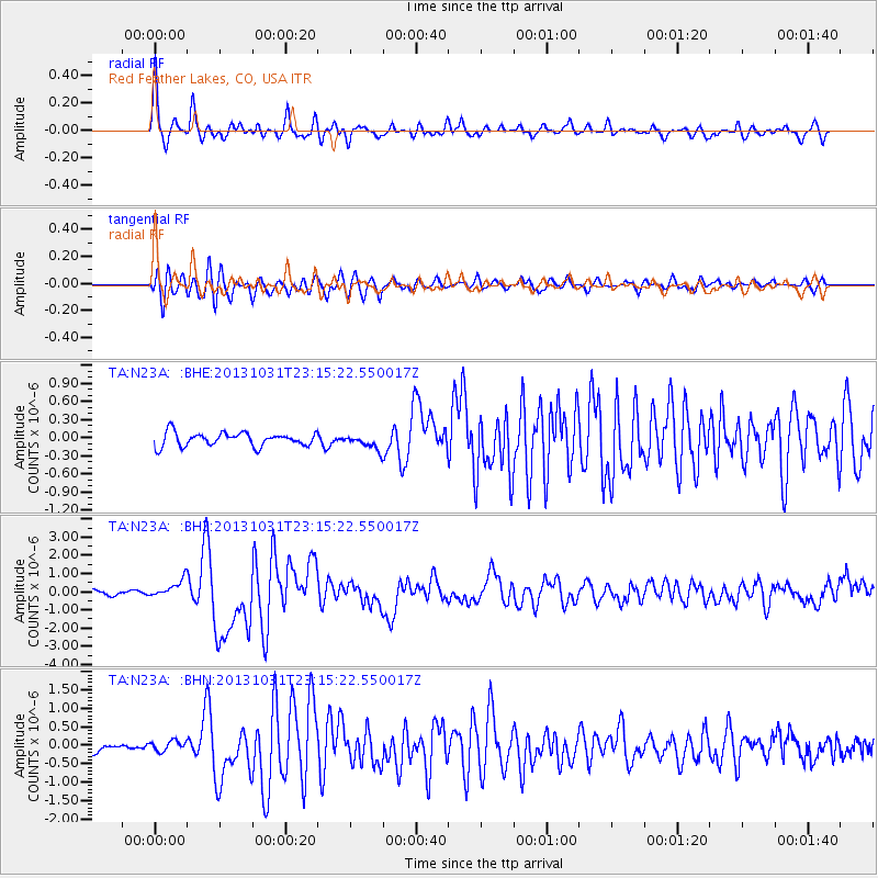
Earthquake location: Near Coast Of Central Chile
Earthquake latitude/longitude: -30.3/-71.5
Earthquake time(UTC): 2013/10/31 (304) 23:03:59 GMT
Earthquake Depth: 27 km
Earthquake Magnitude: 6.6 MWW, 6.4 MWB, 6.5 MWC, 6.6 MWW, 6.6 MI
Earthquake Catalog/Contributor: NEIC PDE/NEIC COMCAT
Network: TA USArray Transportable Network (new EarthScope stations)
Station: N23A Red Feather Lakes, CO, USA
Lat/Lon: 40.89 N/105.94 W
Elevation: 2458 m
Distance: 77.7 deg
Az: 333.982 deg
Baz: 149.968 deg
Ray Param: 0.050132137
Estimated Moho Depth: 47.75 km
Estimated Crust Vp/Vs: 1.73
Assumed Crust Vp: 6.306 km/s
Estimated Crust Vs: 3.656 km/s
Estimated Crust Poisson's Ratio: 0.25
Radial Match: 90.59987 %
Radial Bump: 400
Transverse Match: 84.47084 %
Transverse Bump: 400
SOD ConfigId: 626651
Insert Time: 2014-04-19 09:17:45.247 +0000
GWidth: 2.5
Max Bumps: 400
Tol: 0.001

Signal To Noise

ChannelStoNSTALTA
TA:N23A: :BHZ:20131031T23:15:22.550017Z3.86137964.793159E-71.2413074E-7
TA:N23A: :BHN:20131031T23:15:22.550017Z1.3190571.5493788E-71.1746109E-7
TA:N23A: :BHE:20131031T23:15:22.550017Z1.08591581.2083986E-71.1127921E-7
Arrivals
Ps5.7 SECOND
PpPs20 SECOND
PsPs/PpSs26 SECOND