N48A Decatur, IN, USA - Earthquake Result Viewer
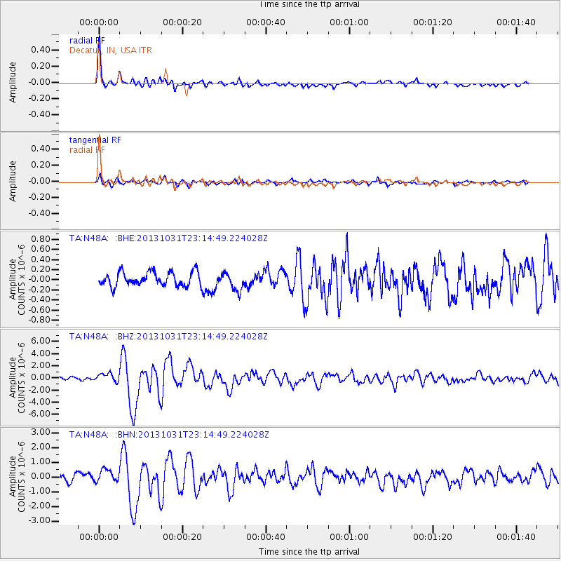
Earthquake location: Near Coast Of Central Chile
Earthquake latitude/longitude: -30.3/-71.5
Earthquake time(UTC): 2013/10/31 (304) 23:03:59 GMT
Earthquake Depth: 27 km
Earthquake Magnitude: 6.6 MWW, 6.4 MWB, 6.5 MWC, 6.6 MWW, 6.6 MI
Earthquake Catalog/Contributor: NEIC PDE/NEIC COMCAT
Network: TA USArray Transportable Network (new EarthScope stations)
Station: N48A Decatur, IN, USA
Lat/Lon: 40.86 N/85.03 W
Elevation: 250 m
Distance: 71.9 deg
Az: 349.259 deg
Baz: 167.73 deg
Ray Param: 0.05398992
Estimated Moho Depth: 33.5 km
Estimated Crust Vp/Vs: 1.94
Assumed Crust Vp: 6.498 km/s
Estimated Crust Vs: 3.354 km/s
Estimated Crust Poisson's Ratio: 0.32
Radial Match: 91.440544 %
Radial Bump: 400
Transverse Match: 82.41231 %
Transverse Bump: 400
SOD ConfigId: 626651
Insert Time: 2014-04-19 09:17:54.150 +0000
GWidth: 2.5
Max Bumps: 400
Tol: 0.001

Signal To Noise

ChannelStoNSTALTA
TA:N48A: :BHZ:20131031T23:14:49.224028Z3.29720976.996215E-72.1218592E-7
TA:N48A: :BHN:20131031T23:14:49.224028Z2.10887314.4883026E-72.1282945E-7
TA:N48A: :BHE:20131031T23:14:49.224028Z1.29875791.7808138E-71.3711669E-7
Arrivals
Ps5.0 SECOND
PpPs15 SECOND
PsPs/PpSs20 SECOND