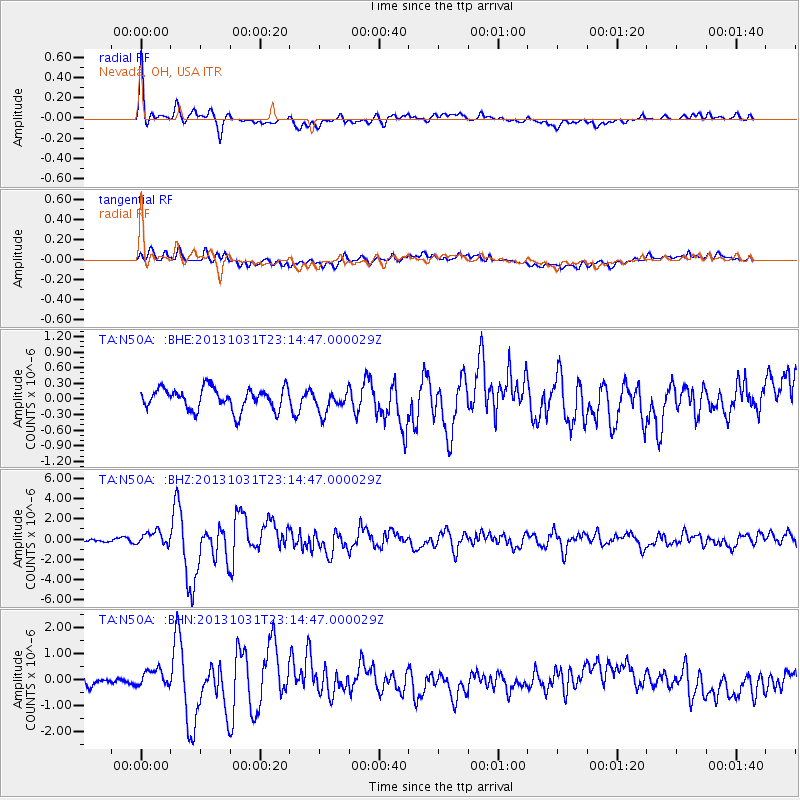
N50A Nevada, OH, USA - Earthquake Result Viewer
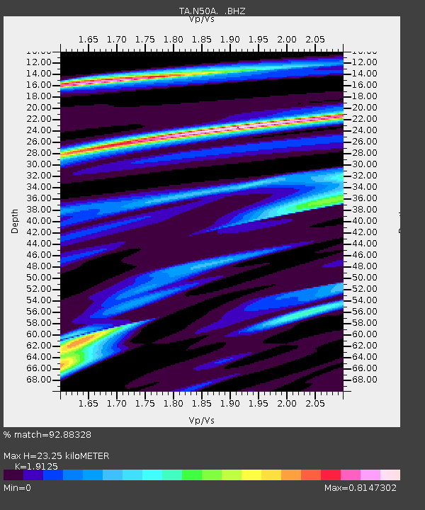
Earthquake location: Near Coast Of Central Chile
Earthquake latitude/longitude: -30.3/-71.5
Earthquake time(UTC): 2013/10/31 (304) 23:03:59 GMT
Earthquake Depth: 27 km
Earthquake Magnitude: 6.6 MWW, 6.4 MWB, 6.5 MWC, 6.6 MWW, 6.6 MI
Earthquake Catalog/Contributor: NEIC PDE/NEIC COMCAT
Network: TA USArray Transportable Network (new EarthScope stations)
Station: N50A Nevada, OH, USA
Lat/Lon: 40.77 N/83.15 W
Elevation: 277 m
Distance: 71.5 deg
Az: 350.712 deg
Baz: 169.409 deg
Ray Param: 0.05423622
Estimated Moho Depth: 23.25 km
Estimated Crust Vp/Vs: 1.91
Assumed Crust Vp: 6.498 km/s
Estimated Crust Vs: 3.397 km/s
Estimated Crust Poisson's Ratio: 0.31
Radial Match: 92.88328 %
Radial Bump: 400
Transverse Match: 76.89322 %
Transverse Bump: 400
SOD ConfigId: 626651
Insert Time: 2014-04-19 09:17:59.584 +0000
GWidth: 2.5
Max Bumps: 400
Tol: 0.001

Signal To Noise

ChannelStoNSTALTA
TA:N50A: :BHZ:20131031T23:14:47.000029Z4.86461546.543483E-71.3451182E-7
TA:N50A: :BHN:20131031T23:14:47.000029Z1.50844553.1608855E-72.0954587E-7
TA:N50A: :BHE:20131031T23:14:47.000029Z1.02787212.1163517E-72.0589641E-7
Arrivals
Ps3.4 SECOND
PpPs10 SECOND
PsPs/PpSs13 SECOND