P48A Milroy, IN, USA - Earthquake Result Viewer
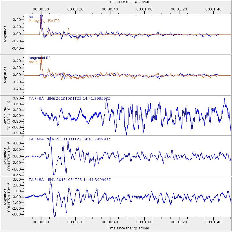
Earthquake location: Near Coast Of Central Chile
Earthquake latitude/longitude: -30.3/-71.5
Earthquake time(UTC): 2013/10/31 (304) 23:03:59 GMT
Earthquake Depth: 27 km
Earthquake Magnitude: 6.6 MWW, 6.4 MWB, 6.5 MWC, 6.6 MWW, 6.6 MI
Earthquake Catalog/Contributor: NEIC PDE/NEIC COMCAT
Network: TA USArray Transportable Network (new EarthScope stations)
Station: P48A Milroy, IN, USA
Lat/Lon: 39.46 N/85.43 W
Elevation: 300 m
Distance: 70.6 deg
Az: 348.625 deg
Baz: 167.27 deg
Ray Param: 0.054844122
Estimated Moho Depth: 30.25 km
Estimated Crust Vp/Vs: 1.94
Assumed Crust Vp: 6.498 km/s
Estimated Crust Vs: 3.354 km/s
Estimated Crust Poisson's Ratio: 0.32
Radial Match: 90.81825 %
Radial Bump: 400
Transverse Match: 75.7309 %
Transverse Bump: 400
SOD ConfigId: 626651
Insert Time: 2014-04-19 09:19:11.718 +0000
GWidth: 2.5
Max Bumps: 400
Tol: 0.001

Signal To Noise

ChannelStoNSTALTA
TA:P48A: :BHZ:20131031T23:14:41.399993Z4.2298718.263963E-71.9537151E-7
TA:P48A: :BHN:20131031T23:14:41.399993Z2.51024755.203551E-72.0729236E-7
TA:P48A: :BHE:20131031T23:14:41.399993Z0.56165661.0401016E-71.8518463E-7
Arrivals
Ps4.5 SECOND
PpPs13 SECOND
PsPs/PpSs18 SECOND