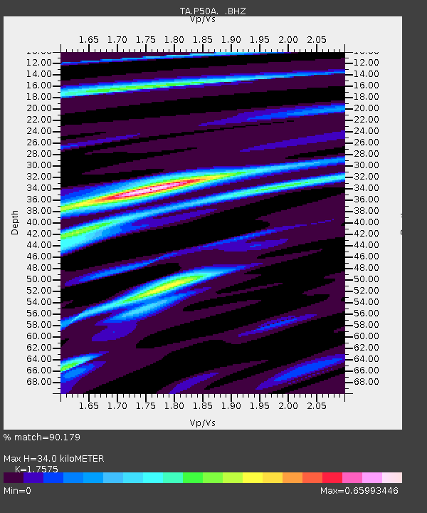
P50A Jamestown, OH, USA - Earthquake Result Viewer

Earthquake location: Near Coast Of Central Chile
Earthquake latitude/longitude: -30.3/-71.5
Earthquake time(UTC): 2013/10/31 (304) 23:03:59 GMT
Earthquake Depth: 27 km
Earthquake Magnitude: 6.6 MWW, 6.4 MWB, 6.5 MWC, 6.6 MWW, 6.6 MI
Earthquake Catalog/Contributor: NEIC PDE/NEIC COMCAT
Network: TA USArray Transportable Network (new EarthScope stations)
Station: P50A Jamestown, OH, USA
Lat/Lon: 39.61 N/83.80 W
Elevation: 318 m
Distance: 70.5 deg
Az: 349.963 deg
Baz: 168.747 deg
Ray Param: 0.054921485
Estimated Moho Depth: 34.0 km
Estimated Crust Vp/Vs: 1.76
Assumed Crust Vp: 6.232 km/s
Estimated Crust Vs: 3.546 km/s
Estimated Crust Poisson's Ratio: 0.26
Radial Match: 90.179 %
Radial Bump: 400
Transverse Match: 73.45325 %
Transverse Bump: 400
SOD ConfigId: 626651
Insert Time: 2014-04-19 09:19:17.179 +0000
GWidth: 2.5
Max Bumps: 400
Tol: 0.001

Signal To Noise

ChannelStoNSTALTA
TA:P50A: :BHZ:20131031T23:14:40.675017Z3.50034486.132885E-71.7520803E-7
TA:P50A: :BHN:20131031T23:14:40.675017Z1.84569294.0853152E-72.2134317E-7
TA:P50A: :BHE:20131031T23:14:40.675017Z0.852898841.4206108E-71.6656264E-7
Arrivals
Ps4.3 SECOND
PpPs15 SECOND
PsPs/PpSs19 SECOND