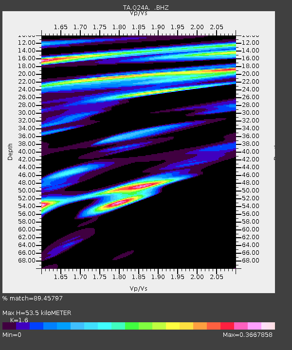
Q24A Divide, CO, USA - Earthquake Result Viewer
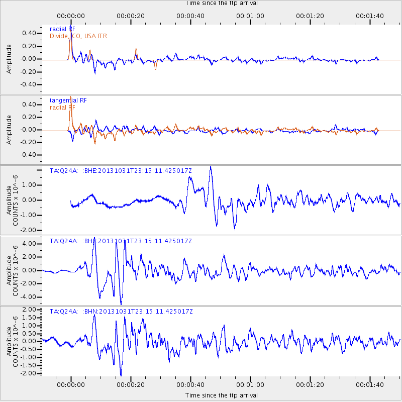
Earthquake location: Near Coast Of Central Chile
Earthquake latitude/longitude: -30.3/-71.5
Earthquake time(UTC): 2013/10/31 (304) 23:03:59 GMT
Earthquake Depth: 27 km
Earthquake Magnitude: 6.6 MWW, 6.4 MWB, 6.5 MWC, 6.6 MWW, 6.6 MI
Earthquake Catalog/Contributor: NEIC PDE/NEIC COMCAT
Network: TA USArray Transportable Network (new EarthScope stations)
Station: Q24A Divide, CO, USA
Lat/Lon: 38.96 N/105.15 W
Elevation: 2775 m
Distance: 75.7 deg
Az: 333.541 deg
Baz: 150.374 deg
Ray Param: 0.05146342
Estimated Moho Depth: 53.5 km
Estimated Crust Vp/Vs: 1.60
Assumed Crust Vp: 6.159 km/s
Estimated Crust Vs: 3.849 km/s
Estimated Crust Poisson's Ratio: 0.18
Radial Match: 89.45797 %
Radial Bump: 335
Transverse Match: 71.773575 %
Transverse Bump: 400
SOD ConfigId: 626651
Insert Time: 2014-04-19 09:19:46.318 +0000
GWidth: 2.5
Max Bumps: 400
Tol: 0.001

Signal To Noise

ChannelStoNSTALTA
TA:Q24A: :BHZ:20131031T23:15:11.425017Z3.2929935.2019016E-71.579688E-7
TA:Q24A: :BHN:20131031T23:15:11.425017Z0.745061642.0418085E-72.740456E-7
TA:Q24A: :BHE:20131031T23:15:11.425017Z1.33831732.974874E-72.2228465E-7
Arrivals
Ps5.4 SECOND
PpPs22 SECOND
PsPs/PpSs27 SECOND