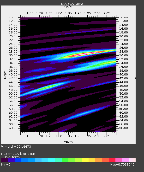
Q50A Georgetown, OH, USA - Earthquake Result Viewer
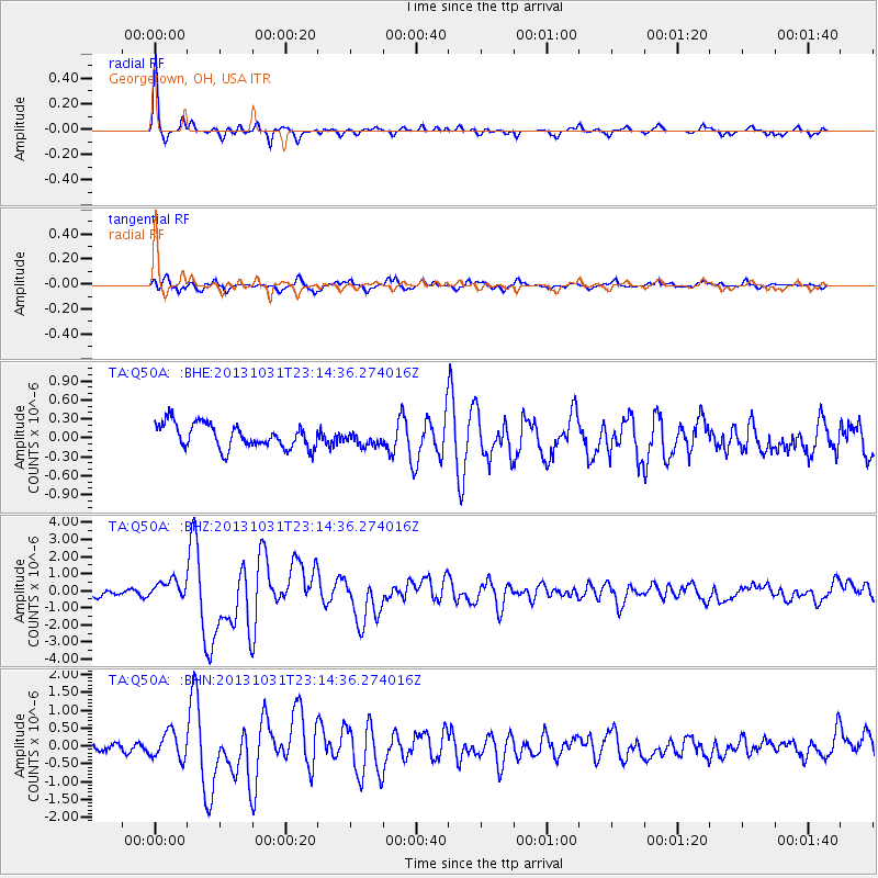
Earthquake location: Near Coast Of Central Chile
Earthquake latitude/longitude: -30.3/-71.5
Earthquake time(UTC): 2013/10/31 (304) 23:03:59 GMT
Earthquake Depth: 27 km
Earthquake Magnitude: 6.6 MWW, 6.4 MWB, 6.5 MWC, 6.6 MWW, 6.6 MI
Earthquake Catalog/Contributor: NEIC PDE/NEIC COMCAT
Network: TA USArray Transportable Network (new EarthScope stations)
Station: Q50A Georgetown, OH, USA
Lat/Lon: 38.84 N/83.98 W
Elevation: 262 m
Distance: 69.8 deg
Az: 349.657 deg
Baz: 168.529 deg
Ray Param: 0.05539964
Estimated Moho Depth: 29.0 km
Estimated Crust Vp/Vs: 1.94
Assumed Crust Vp: 6.232 km/s
Estimated Crust Vs: 3.216 km/s
Estimated Crust Poisson's Ratio: 0.32
Radial Match: 92.16673 %
Radial Bump: 272
Transverse Match: 64.499504 %
Transverse Bump: 400
SOD ConfigId: 626651
Insert Time: 2014-04-19 09:19:51.938 +0000
GWidth: 2.5
Max Bumps: 400
Tol: 0.001

Signal To Noise

ChannelStoNSTALTA
TA:Q50A: :BHZ:20131031T23:14:36.274016Z2.5682715.574795E-72.1706414E-7
TA:Q50A: :BHN:20131031T23:14:36.274016Z2.70418143.708074E-71.3712372E-7
TA:Q50A: :BHE:20131031T23:14:36.274016Z0.59078961.1324993E-71.916925E-7
Arrivals
Ps4.5 SECOND
PpPs13 SECOND
PsPs/PpSs18 SECOND