You are here: Home > Network List > TA - USArray Transportable Network (new EarthScope stations) Stations List
> Station Q58A Fox Den Farm, The Plains, VA, USA > Earthquake Result Viewer
Q58A Fox Den Farm, The Plains, VA, USA - Earthquake Result Viewer

| Earthquake location: |
Near Coast Of Central Chile |
| Earthquake latitude/longitude: |
-30.3/-71.5 |
| Earthquake time(UTC): |
2013/10/31 (304) 23:03:59 GMT |
| Earthquake Depth: |
27 km |
| Earthquake Magnitude: |
6.6 MWW, 6.4 MWB, 6.5 MWC, 6.6 MWW, 6.6 MI |
| Earthquake Catalog/Contributor: |
NEIC PDE/NEIC COMCAT |
|
| Network: |
TA USArray Transportable Network (new EarthScope stations) |
| Station: |
Q58A Fox Den Farm, The Plains, VA, USA |
| Lat/Lon: |
38.94 N/77.68 W |
| Elevation: |
182 m |
|
| Distance: |
69.1 deg |
| Az: |
354.861 deg |
| Baz: |
174.299 deg |
| Ray Param: |
0.055823125 |
| Estimated Moho Depth: |
24.0 km |
| Estimated Crust Vp/Vs: |
1.60 |
| Assumed Crust Vp: |
6.419 km/s |
| Estimated Crust Vs: |
4.012 km/s |
| Estimated Crust Poisson's Ratio: |
0.18 |
|
| Radial Match: |
96.42535 % |
| Radial Bump: |
267 |
| Transverse Match: |
90.92094 % |
| Transverse Bump: |
400 |
| SOD ConfigId: |
626651 |
| Insert Time: |
2014-04-19 09:20:12.803 +0000 |
| GWidth: |
2.5 |
| Max Bumps: |
400 |
| Tol: |
0.001 |
|
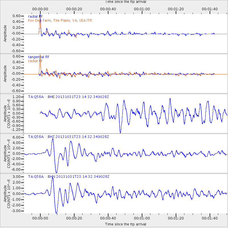
Signal To Noise
| Channel | StoN | STA | LTA |
| TA:Q58A: :BHZ:20131031T23:14:32.349028Z | 3.497559 | 7.391175E-7 | 2.1132381E-7 |
| TA:Q58A: :BHN:20131031T23:14:32.349028Z | 3.6721535 | 3.655058E-7 | 9.953446E-8 |
| TA:Q58A: :BHE:20131031T23:14:32.349028Z | 0.73901385 | 1.2149377E-7 | 1.6439985E-7 |
| Arrivals |
| Ps | 2.3 SECOND |
| PpPs | 9.3 SECOND |
| PsPs/PpSs | 12 SECOND |


