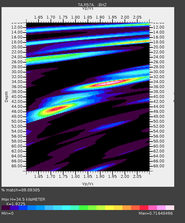
R57A Stanardsville, VA, USA - Earthquake Result Viewer

Earthquake location: Near Coast Of Central Chile
Earthquake latitude/longitude: -30.3/-71.5
Earthquake time(UTC): 2013/10/31 (304) 23:03:59 GMT
Earthquake Depth: 27 km
Earthquake Magnitude: 6.6 MWW, 6.4 MWB, 6.5 MWC, 6.6 MWW, 6.6 MI
Earthquake Catalog/Contributor: NEIC PDE/NEIC COMCAT
Network: TA USArray Transportable Network (new EarthScope stations)
Station: R57A Stanardsville, VA, USA
Lat/Lon: 38.30 N/78.52 W
Elevation: 230 m
Distance: 68.5 deg
Az: 354.085 deg
Baz: 173.495 deg
Ray Param: 0.05619552
Estimated Moho Depth: 34.5 km
Estimated Crust Vp/Vs: 1.92
Assumed Crust Vp: 6.159 km/s
Estimated Crust Vs: 3.203 km/s
Estimated Crust Poisson's Ratio: 0.31
Radial Match: 89.89385 %
Radial Bump: 295
Transverse Match: 81.69102 %
Transverse Bump: 400
SOD ConfigId: 626651
Insert Time: 2014-04-19 09:20:41.825 +0000
GWidth: 2.5
Max Bumps: 400
Tol: 0.001

Signal To Noise

ChannelStoNSTALTA
TA:R57A: :BHZ:20131031T23:14:28.800017Z4.11104257.640921E-71.8586334E-7
TA:R57A: :BHN:20131031T23:14:28.800017Z1.30534672.9505065E-72.260324E-7
TA:R57A: :BHE:20131031T23:14:28.800017Z0.58510339.326742E-81.5940333E-7
Arrivals
Ps5.3 SECOND
PpPs16 SECOND
PsPs/PpSs21 SECOND