S49A Springfield, KY, USA - Earthquake Result Viewer
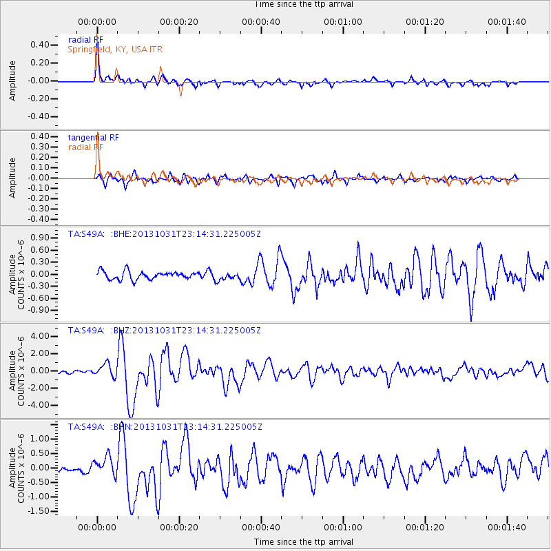
Earthquake location: Near Coast Of Central Chile
Earthquake latitude/longitude: -30.3/-71.5
Earthquake time(UTC): 2013/10/31 (304) 23:03:59 GMT
Earthquake Depth: 27 km
Earthquake Magnitude: 6.6 MWW, 6.4 MWB, 6.5 MWC, 6.6 MWW, 6.6 MI
Earthquake Catalog/Contributor: NEIC PDE/NEIC COMCAT
Network: TA USArray Transportable Network (new EarthScope stations)
Station: S49A Springfield, KY, USA
Lat/Lon: 37.78 N/85.29 W
Elevation: 230 m
Distance: 68.9 deg
Az: 348.344 deg
Baz: 167.258 deg
Ray Param: 0.055940814
Estimated Moho Depth: 38.25 km
Estimated Crust Vp/Vs: 1.80
Assumed Crust Vp: 6.476 km/s
Estimated Crust Vs: 3.598 km/s
Estimated Crust Poisson's Ratio: 0.28
Radial Match: 92.50141 %
Radial Bump: 400
Transverse Match: 86.53608 %
Transverse Bump: 400
SOD ConfigId: 626651
Insert Time: 2014-04-19 09:21:03.410 +0000
GWidth: 2.5
Max Bumps: 400
Tol: 0.001

Signal To Noise

ChannelStoNSTALTA
TA:S49A: :BHZ:20131031T23:14:31.225005Z3.31803277.5418245E-72.2729809E-7
TA:S49A: :BHN:20131031T23:14:31.225005Z2.82883883.525792E-71.2463742E-7
TA:S49A: :BHE:20131031T23:14:31.225005Z0.93813229.376935E-89.995323E-8
Arrivals
Ps4.9 SECOND
PpPs16 SECOND
PsPs/PpSs21 SECOND