You are here: Home > Network List > TA - USArray Transportable Network (new EarthScope stations) Stations List
> Station S54A Dingess, Beckley, WV, USA > Earthquake Result Viewer
S54A Dingess, Beckley, WV, USA - Earthquake Result Viewer
| Earthquake location: |
Near Coast Of Central Chile |
| Earthquake latitude/longitude: |
-30.3/-71.5 |
| Earthquake time(UTC): |
2013/10/31 (304) 23:03:59 GMT |
| Earthquake Depth: |
27 km |
| Earthquake Magnitude: |
6.6 MWW, 6.4 MWB, 6.5 MWC, 6.6 MWW, 6.6 MI |
| Earthquake Catalog/Contributor: |
NEIC PDE/NEIC COMCAT |
|
| Network: |
TA USArray Transportable Network (new EarthScope stations) |
| Station: |
S54A Dingess, Beckley, WV, USA |
| Lat/Lon: |
37.80 N/81.31 W |
| Elevation: |
636 m |
|
| Distance: |
68.4 deg |
| Az: |
351.668 deg |
| Baz: |
170.896 deg |
| Ray Param: |
0.056321632 |
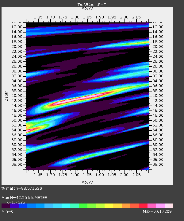
| Estimated Moho Depth: |
42.25 km |
| Estimated Crust Vp/Vs: |
1.75 |
| Assumed Crust Vp: |
6.159 km/s |
| Estimated Crust Vs: |
3.514 km/s |
| Estimated Crust Poisson's Ratio: |
0.26 |
|
| Radial Match: |
88.571526 % |
| Radial Bump: |
331 |
| Transverse Match: |
69.13972 % |
| Transverse Bump: |
400 |
| SOD ConfigId: |
626651 |
| Insert Time: |
2014-04-19 09:21:12.435 +0000 |
| GWidth: |
2.5 |
| Max Bumps: |
400 |
| Tol: |
0.001 |
|
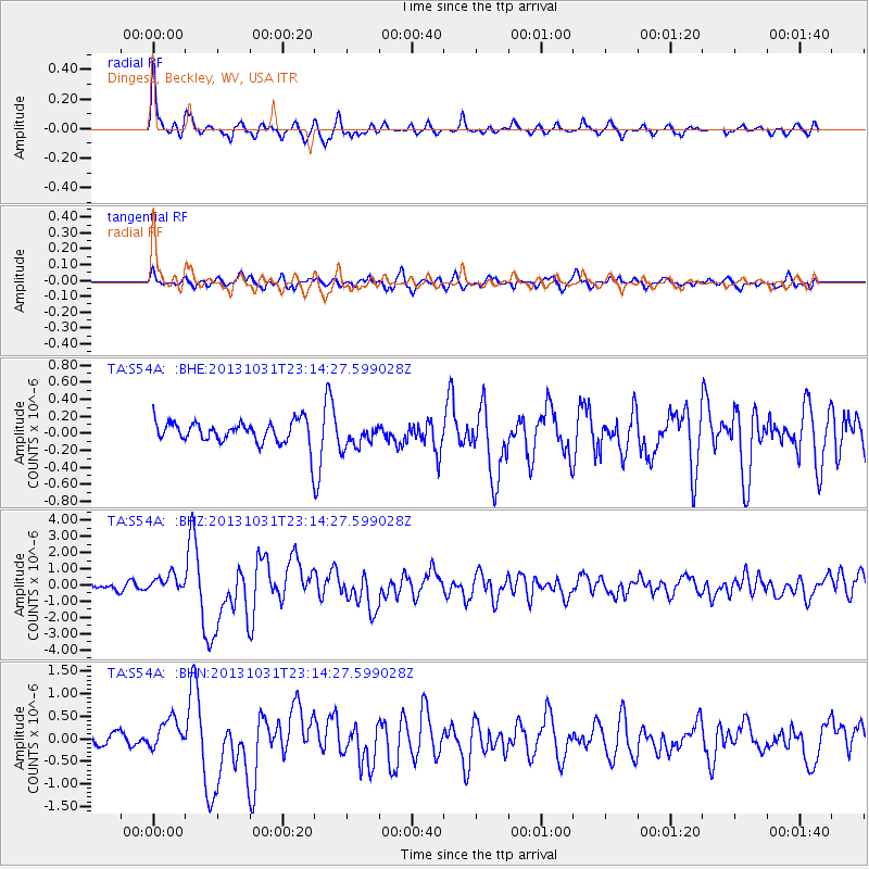
Signal To Noise
| Channel | StoN | STA | LTA |
| TA:S54A: :BHZ:20131031T23:14:27.599028Z | 3.2295127 | 5.3466607E-7 | 1.6555627E-7 |
| TA:S54A: :BHN:20131031T23:14:27.599028Z | 2.3698733 | 3.5261638E-7 | 1.4879123E-7 |
| TA:S54A: :BHE:20131031T23:14:27.599028Z | 1.1167332 | 1.4691135E-7 | 1.3155456E-7 |
| Arrivals |
| Ps | 5.4 SECOND |
| PpPs | 18 SECOND |
| PsPs/PpSs | 24 SECOND |


