T60A Surry, VA, USA - Earthquake Result Viewer
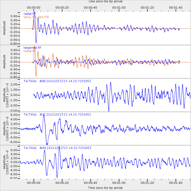
Earthquake location: Near Coast Of Central Chile
Earthquake latitude/longitude: -30.3/-71.5
Earthquake time(UTC): 2013/10/31 (304) 23:03:59 GMT
Earthquake Depth: 27 km
Earthquake Magnitude: 6.6 MWW, 6.4 MWB, 6.5 MWC, 6.6 MWW, 6.6 MI
Earthquake Catalog/Contributor: NEIC PDE/NEIC COMCAT
Network: TA USArray Transportable Network (new EarthScope stations)
Station: T60A Surry, VA, USA
Lat/Lon: 37.14 N/76.73 W
Elevation: 11 m
Distance: 67.3 deg
Az: 355.484 deg
Baz: 175.111 deg
Ray Param: 0.05703714
Estimated Moho Depth: 53.75 km
Estimated Crust Vp/Vs: 1.91
Assumed Crust Vp: 6.565 km/s
Estimated Crust Vs: 3.428 km/s
Estimated Crust Poisson's Ratio: 0.31
Radial Match: 94.30998 %
Radial Bump: 400
Transverse Match: 74.08744 %
Transverse Bump: 400
SOD ConfigId: 626651
Insert Time: 2014-04-19 09:22:15.174 +0000
GWidth: 2.5
Max Bumps: 400
Tol: 0.001

Signal To Noise

ChannelStoNSTALTA
TA:T60A: :BHZ:20131031T23:14:20.725005Z5.2306848.252625E-71.5777334E-7
TA:T60A: :BHN:20131031T23:14:20.725005Z1.77512517.125352E-74.014E-7
TA:T60A: :BHE:20131031T23:14:20.725005Z1.38648134.761239E-73.4340448E-7
Arrivals
Ps7.8 SECOND
PpPs23 SECOND
PsPs/PpSs31 SECOND