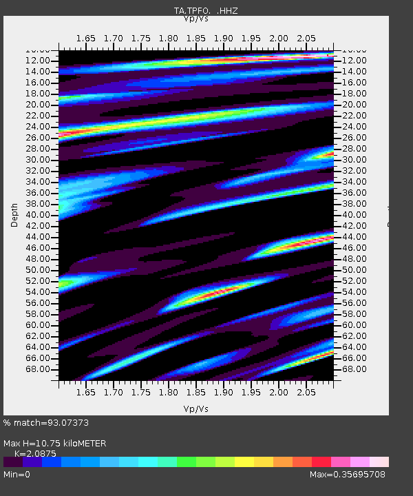
TPFO Pinon Flats, CA, USA - Earthquake Result Viewer

Earthquake location: Near Coast Of Central Chile
Earthquake latitude/longitude: -30.3/-71.5
Earthquake time(UTC): 2013/10/31 (304) 23:03:59 GMT
Earthquake Depth: 27 km
Earthquake Magnitude: 6.6 MWW, 6.4 MWB, 6.5 MWC, 6.6 MWW, 6.6 MI
Earthquake Catalog/Contributor: NEIC PDE/NEIC COMCAT
Network: TA USArray Transportable Network (new EarthScope stations)
Station: TPFO Pinon Flats, CA, USA
Lat/Lon: 33.61 N/116.45 W
Elevation: 1275 m
Distance: 76.4 deg
Az: 322.674 deg
Baz: 141.067 deg
Ray Param: 0.050961927
Estimated Moho Depth: 10.75 km
Estimated Crust Vp/Vs: 2.09
Assumed Crust Vp: 6.264 km/s
Estimated Crust Vs: 3.001 km/s
Estimated Crust Poisson's Ratio: 0.35
Radial Match: 93.07373 %
Radial Bump: 278
Transverse Match: 85.84243 %
Transverse Bump: 400
SOD ConfigId: 626651
Insert Time: 2014-04-19 09:22:20.337 +0000
GWidth: 2.5
Max Bumps: 400
Tol: 0.001

Signal To Noise

ChannelStoNSTALTA
TA:TPFO: :HHZ:20131031T23:15:15.649993Z2.3000663.269461E-71.4214639E-7
TA:TPFO: :HHN:20131031T23:15:15.649993Z2.17040851.6690748E-77.6901415E-8
TA:TPFO: :HHE:20131031T23:15:15.649993Z0.81767478.312386E-81.0165883E-7
Arrivals
Ps1.9 SECOND
PpPs5.2 SECOND
PsPs/PpSs7.1 SECOND