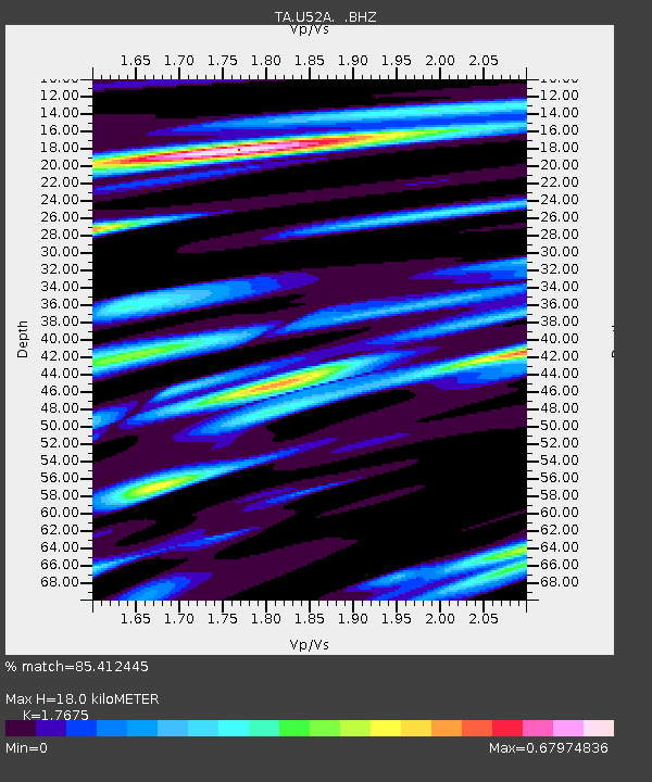
U52A Thorn Hill, TN, USA - Earthquake Result Viewer
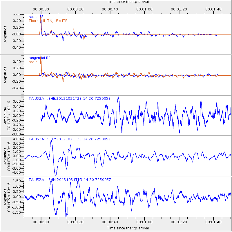
Earthquake location: Near Coast Of Central Chile
Earthquake latitude/longitude: -30.3/-71.5
Earthquake time(UTC): 2013/10/31 (304) 23:03:59 GMT
Earthquake Depth: 27 km
Earthquake Magnitude: 6.6 MWW, 6.4 MWB, 6.5 MWC, 6.6 MWW, 6.6 MI
Earthquake Catalog/Contributor: NEIC PDE/NEIC COMCAT
Network: TA USArray Transportable Network (new EarthScope stations)
Station: U52A Thorn Hill, TN, USA
Lat/Lon: 36.39 N/83.37 W
Elevation: 510 m
Distance: 67.3 deg
Az: 349.654 deg
Baz: 168.901 deg
Ray Param: 0.05703496
Estimated Moho Depth: 18.0 km
Estimated Crust Vp/Vs: 1.77
Assumed Crust Vp: 6.476 km/s
Estimated Crust Vs: 3.664 km/s
Estimated Crust Poisson's Ratio: 0.26
Radial Match: 85.412445 %
Radial Bump: 312
Transverse Match: 72.7716 %
Transverse Bump: 400
SOD ConfigId: 626651
Insert Time: 2014-04-19 09:22:34.710 +0000
GWidth: 2.5
Max Bumps: 400
Tol: 0.001

Signal To Noise

ChannelStoNSTALTA
TA:U52A: :BHZ:20131031T23:14:20.725005Z2.86548736.5444306E-72.2838805E-7
TA:U52A: :BHN:20131031T23:14:20.725005Z0.93797361.9162293E-72.0429458E-7
TA:U52A: :BHE:20131031T23:14:20.725005Z0.51476848.4821096E-81.6477524E-7
Arrivals
Ps2.2 SECOND
PpPs7.4 SECOND
PsPs/PpSs9.6 SECOND