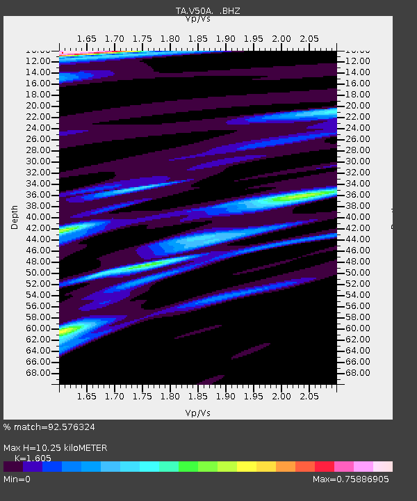
V50A Pikevile, TN, USA - Earthquake Result Viewer
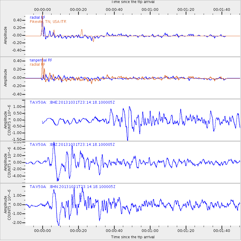
Earthquake location: Near Coast Of Central Chile
Earthquake latitude/longitude: -30.3/-71.5
Earthquake time(UTC): 2013/10/31 (304) 23:03:59 GMT
Earthquake Depth: 27 km
Earthquake Magnitude: 6.6 MWW, 6.4 MWB, 6.5 MWC, 6.6 MWW, 6.6 MI
Earthquake Catalog/Contributor: NEIC PDE/NEIC COMCAT
Network: TA USArray Transportable Network (new EarthScope stations)
Station: V50A Pikevile, TN, USA
Lat/Lon: 35.67 N/85.10 W
Elevation: 287 m
Distance: 66.8 deg
Az: 348.0 deg
Baz: 167.241 deg
Ray Param: 0.057306714
Estimated Moho Depth: 10.25 km
Estimated Crust Vp/Vs: 1.61
Assumed Crust Vp: 6.35 km/s
Estimated Crust Vs: 3.956 km/s
Estimated Crust Poisson's Ratio: 0.18
Radial Match: 92.576324 %
Radial Bump: 400
Transverse Match: 85.17369 %
Transverse Bump: 400
SOD ConfigId: 626651
Insert Time: 2014-04-19 09:23:01.267 +0000
GWidth: 2.5
Max Bumps: 400
Tol: 0.001

Signal To Noise

ChannelStoNSTALTA
TA:V50A: :BHZ:20131031T23:14:18.100005Z3.88817866.6808417E-71.7182447E-7
TA:V50A: :BHN:20131031T23:14:18.100005Z1.3437151.7767617E-71.3222758E-7
TA:V50A: :BHE:20131031T23:14:18.100005Z0.928544041.4088248E-71.5172407E-7
Arrivals
Ps1.0 SECOND
PpPs4.0 SECOND
PsPs/PpSs5.0 SECOND