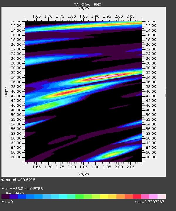
V55A Taylorsville, NC, USA - Earthquake Result Viewer
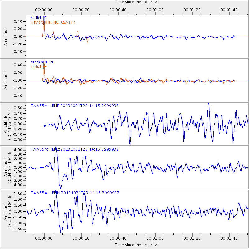
Earthquake location: Near Coast Of Central Chile
Earthquake latitude/longitude: -30.3/-71.5
Earthquake time(UTC): 2013/10/31 (304) 23:03:59 GMT
Earthquake Depth: 27 km
Earthquake Magnitude: 6.6 MWW, 6.4 MWB, 6.5 MWC, 6.6 MWW, 6.6 MI
Earthquake Catalog/Contributor: NEIC PDE/NEIC COMCAT
Network: TA USArray Transportable Network (new EarthScope stations)
Station: V55A Taylorsville, NC, USA
Lat/Lon: 35.85 N/81.21 W
Elevation: 306 m
Distance: 66.4 deg
Az: 351.417 deg
Baz: 170.857 deg
Ray Param: 0.057588674
Estimated Moho Depth: 33.5 km
Estimated Crust Vp/Vs: 1.94
Assumed Crust Vp: 6.419 km/s
Estimated Crust Vs: 3.305 km/s
Estimated Crust Poisson's Ratio: 0.32
Radial Match: 93.6215 %
Radial Bump: 396
Transverse Match: 80.09766 %
Transverse Bump: 400
SOD ConfigId: 626651
Insert Time: 2014-04-19 09:23:13.365 +0000
GWidth: 2.5
Max Bumps: 400
Tol: 0.001

Signal To Noise

ChannelStoNSTALTA
TA:V55A: :BHZ:20131031T23:14:15.399993Z4.09114275.693396E-71.3916396E-7
TA:V55A: :BHN:20131031T23:14:15.399993Z1.86672082.7833823E-71.4910545E-7
TA:V55A: :BHE:20131031T23:14:15.399993Z0.86828081.0579932E-71.218492E-7
Arrivals
Ps5.1 SECOND
PpPs15 SECOND
PsPs/PpSs20 SECOND