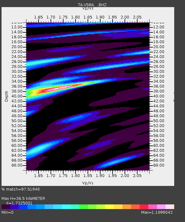
V59A Middlesex, NC, USA - Earthquake Result Viewer
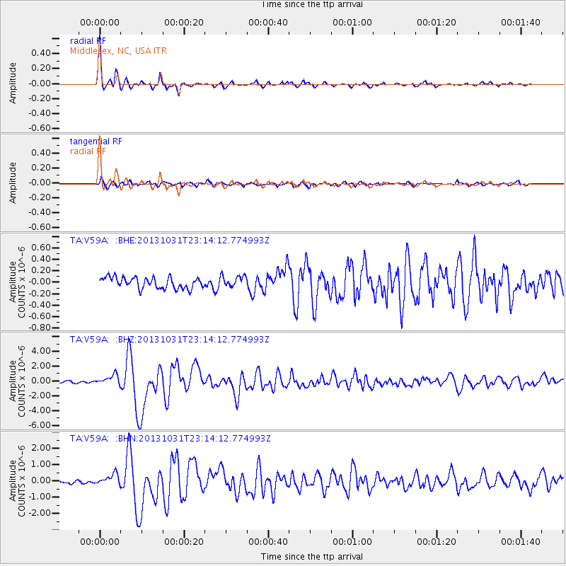
Earthquake location: Near Coast Of Central Chile
Earthquake latitude/longitude: -30.3/-71.5
Earthquake time(UTC): 2013/10/31 (304) 23:03:59 GMT
Earthquake Depth: 27 km
Earthquake Magnitude: 6.6 MWW, 6.4 MWB, 6.5 MWC, 6.6 MWW, 6.6 MI
Earthquake Catalog/Contributor: NEIC PDE/NEIC COMCAT
Network: TA USArray Transportable Network (new EarthScope stations)
Station: V59A Middlesex, NC, USA
Lat/Lon: 35.76 N/78.24 W
Elevation: 58 m
Distance: 66.0 deg
Az: 354.023 deg
Baz: 173.642 deg
Ray Param: 0.057858087
Estimated Moho Depth: 36.5 km
Estimated Crust Vp/Vs: 1.73
Assumed Crust Vp: 6.565 km/s
Estimated Crust Vs: 3.789 km/s
Estimated Crust Poisson's Ratio: 0.25
Radial Match: 97.51948 %
Radial Bump: 306
Transverse Match: 82.629234 %
Transverse Bump: 400
SOD ConfigId: 626651
Insert Time: 2014-04-19 09:23:22.503 +0000
GWidth: 2.5
Max Bumps: 400
Tol: 0.001

Signal To Noise

ChannelStoNSTALTA
TA:V59A: :BHZ:20131031T23:14:12.774993Z6.3071087.1750577E-71.1376145E-7
TA:V59A: :BHN:20131031T23:14:12.774993Z4.415353.4453913E-77.803212E-8
TA:V59A: :BHE:20131031T23:14:12.774993Z1.01699019.7307066E-89.568143E-8
Arrivals
Ps4.3 SECOND
PpPs15 SECOND
PsPs/PpSs19 SECOND