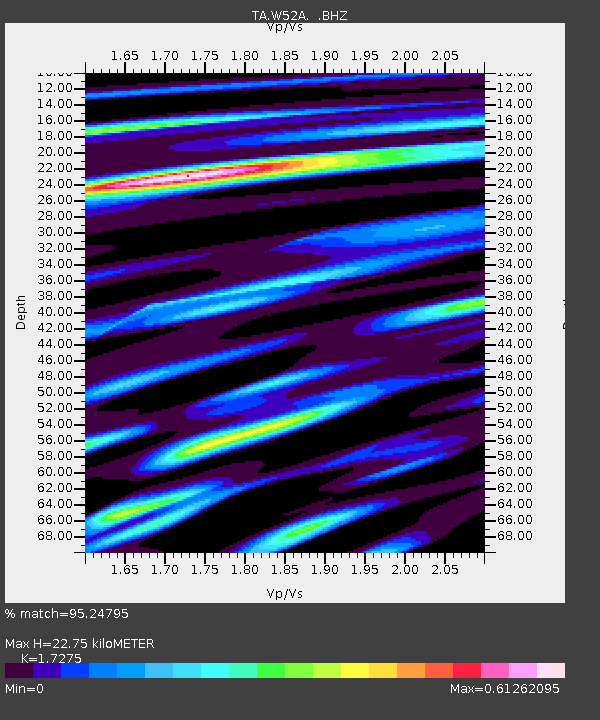
W52A Murphy, NC, USA - Earthquake Result Viewer

Earthquake location: Near Coast Of Central Chile
Earthquake latitude/longitude: -30.3/-71.5
Earthquake time(UTC): 2013/10/31 (304) 23:03:59 GMT
Earthquake Depth: 27 km
Earthquake Magnitude: 6.6 MWW, 6.4 MWB, 6.5 MWC, 6.6 MWW, 6.6 MI
Earthquake Catalog/Contributor: NEIC PDE/NEIC COMCAT
Network: TA USArray Transportable Network (new EarthScope stations)
Station: W52A Murphy, NC, USA
Lat/Lon: 35.09 N/83.93 W
Elevation: 519 m
Distance: 66.1 deg
Az: 348.888 deg
Baz: 168.271 deg
Ray Param: 0.057812843
Estimated Moho Depth: 22.75 km
Estimated Crust Vp/Vs: 1.73
Assumed Crust Vp: 6.35 km/s
Estimated Crust Vs: 3.676 km/s
Estimated Crust Poisson's Ratio: 0.25
Radial Match: 95.24795 %
Radial Bump: 340
Transverse Match: 82.05777 %
Transverse Bump: 400
SOD ConfigId: 626651
Insert Time: 2014-04-19 09:23:44.326 +0000
GWidth: 2.5
Max Bumps: 400
Tol: 0.001

Signal To Noise

ChannelStoNSTALTA
TA:W52A: :BHZ:20131031T23:14:13.225005Z5.8296077.718604E-71.3240351E-7
TA:W52A: :BHN:20131031T23:14:13.225005Z1.85902242.799403E-71.5058468E-7
TA:W52A: :BHE:20131031T23:14:13.225005Z1.37122011.5084603E-71.1000862E-7
Arrivals
Ps2.7 SECOND
PpPs9.4 SECOND
PsPs/PpSs12 SECOND