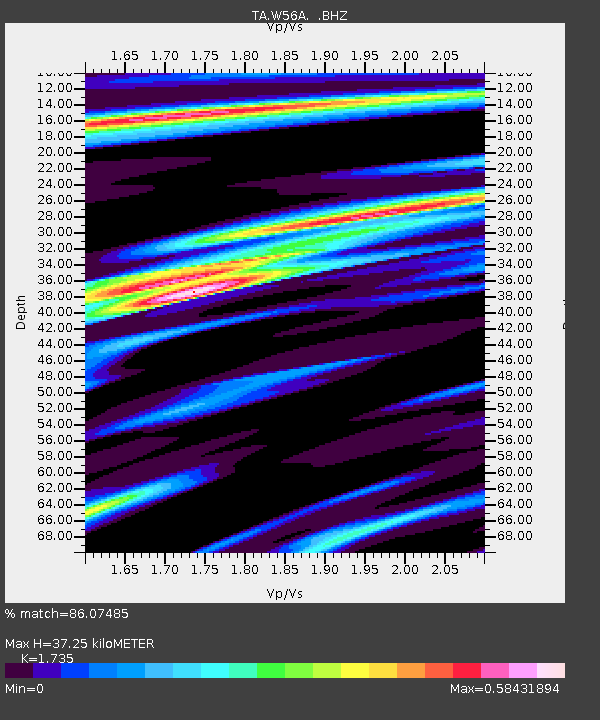
W56A Indian Trail, NC, USA - Earthquake Result Viewer

Earthquake location: Near Coast Of Central Chile
Earthquake latitude/longitude: -30.3/-71.5
Earthquake time(UTC): 2013/10/31 (304) 23:03:59 GMT
Earthquake Depth: 27 km
Earthquake Magnitude: 6.6 MWW, 6.4 MWB, 6.5 MWC, 6.6 MWW, 6.6 MI
Earthquake Catalog/Contributor: NEIC PDE/NEIC COMCAT
Network: TA USArray Transportable Network (new EarthScope stations)
Station: W56A Indian Trail, NC, USA
Lat/Lon: 35.13 N/80.58 W
Elevation: 177 m
Distance: 65.6 deg
Az: 351.854 deg
Baz: 171.4 deg
Ray Param: 0.05810325
Estimated Moho Depth: 37.25 km
Estimated Crust Vp/Vs: 1.74
Assumed Crust Vp: 6.419 km/s
Estimated Crust Vs: 3.7 km/s
Estimated Crust Poisson's Ratio: 0.25
Radial Match: 86.07485 %
Radial Bump: 400
Transverse Match: 64.62301 %
Transverse Bump: 400
SOD ConfigId: 626651
Insert Time: 2014-04-19 09:23:50.541 +0000
GWidth: 2.5
Max Bumps: 400
Tol: 0.001

Signal To Noise

ChannelStoNSTALTA
TA:W56A: :BHZ:20131031T23:14:10.375029Z3.58410745.8163477E-71.6228162E-7
TA:W56A: :BHN:20131031T23:14:10.375029Z1.79880883.840827E-72.1352058E-7
TA:W56A: :BHE:20131031T23:14:10.375029Z0.64894931.2112103E-71.8664174E-7
Arrivals
Ps4.4 SECOND
PpPs15 SECOND
PsPs/PpSs20 SECOND