You are here: Home > Network List > TA - USArray Transportable Network (new EarthScope stations) Stations List
> Station W61A Ground Anchor Farm, New Bern, NC, USA > Earthquake Result Viewer
W61A Ground Anchor Farm, New Bern, NC, USA - Earthquake Result Viewer
| Earthquake location: |
Near Coast Of Central Chile |
| Earthquake latitude/longitude: |
-30.3/-71.5 |
| Earthquake time(UTC): |
2013/10/31 (304) 23:03:59 GMT |
| Earthquake Depth: |
27 km |
| Earthquake Magnitude: |
6.6 MWW, 6.4 MWB, 6.5 MWC, 6.6 MWW, 6.6 MI |
| Earthquake Catalog/Contributor: |
NEIC PDE/NEIC COMCAT |
|
| Network: |
TA USArray Transportable Network (new EarthScope stations) |
| Station: |
W61A Ground Anchor Farm, New Bern, NC, USA |
| Lat/Lon: |
35.18 N/76.99 W |
| Elevation: |
6.0 m |
|
| Distance: |
65.3 deg |
| Az: |
355.071 deg |
| Baz: |
174.795 deg |
| Ray Param: |
0.058307946 |
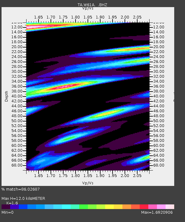
| Estimated Moho Depth: |
12.0 km |
| Estimated Crust Vp/Vs: |
1.60 |
| Assumed Crust Vp: |
6.565 km/s |
| Estimated Crust Vs: |
4.103 km/s |
| Estimated Crust Poisson's Ratio: |
0.18 |
|
| Radial Match: |
86.02687 % |
| Radial Bump: |
400 |
| Transverse Match: |
63.524296 % |
| Transverse Bump: |
400 |
| SOD ConfigId: |
626651 |
| Insert Time: |
2014-04-19 09:24:03.329 +0000 |
| GWidth: |
2.5 |
| Max Bumps: |
400 |
| Tol: |
0.001 |
|
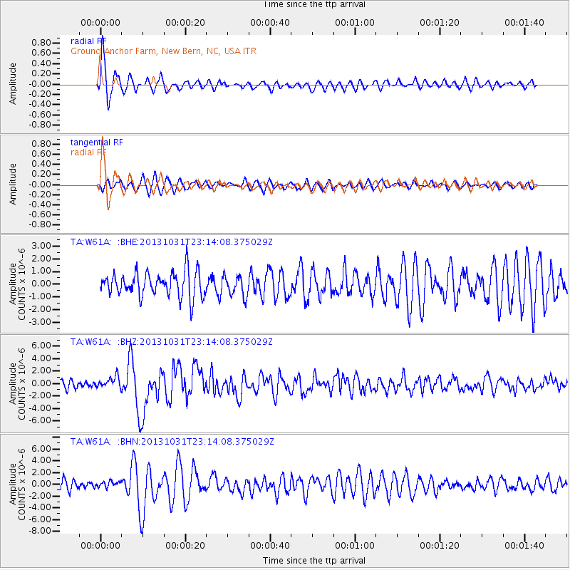
Signal To Noise
| Channel | StoN | STA | LTA |
| TA:W61A: :BHZ:20131031T23:14:08.375029Z | 1.9098686 | 9.674166E-7 | 5.065357E-7 |
| TA:W61A: :BHN:20131031T23:14:08.375029Z | 0.48801297 | 5.2351004E-7 | 1.072738E-6 |
| TA:W61A: :BHE:20131031T23:14:08.375029Z | 0.8427658 | 8.136605E-7 | 9.654646E-7 |
| Arrivals |
| Ps | 1.2 SECOND |
| PpPs | 4.5 SECOND |
| PsPs/PpSs | 5.7 SECOND |


