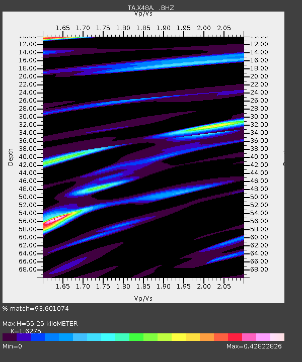
X48A Hartselle, AL, USA - Earthquake Result Viewer
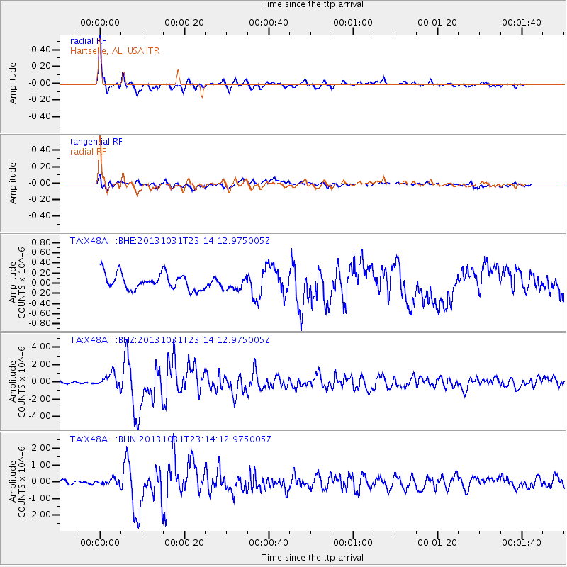
Earthquake location: Near Coast Of Central Chile
Earthquake latitude/longitude: -30.3/-71.5
Earthquake time(UTC): 2013/10/31 (304) 23:03:59 GMT
Earthquake Depth: 27 km
Earthquake Magnitude: 6.6 MWW, 6.4 MWB, 6.5 MWC, 6.6 MWW, 6.6 MI
Earthquake Catalog/Contributor: NEIC PDE/NEIC COMCAT
Network: TA USArray Transportable Network (new EarthScope stations)
Station: X48A Hartselle, AL, USA
Lat/Lon: 34.45 N/87.05 W
Elevation: 180 m
Distance: 66.0 deg
Az: 345.994 deg
Baz: 165.326 deg
Ray Param: 0.057837114
Estimated Moho Depth: 55.25 km
Estimated Crust Vp/Vs: 1.63
Assumed Crust Vp: 6.476 km/s
Estimated Crust Vs: 3.979 km/s
Estimated Crust Poisson's Ratio: 0.20
Radial Match: 93.601074 %
Radial Bump: 314
Transverse Match: 74.43306 %
Transverse Bump: 400
SOD ConfigId: 626651
Insert Time: 2014-04-19 09:24:11.538 +0000
GWidth: 2.5
Max Bumps: 400
Tol: 0.001

Signal To Noise

ChannelStoNSTALTA
TA:X48A: :BHZ:20131031T23:14:12.975005Z6.54626667.7046536E-71.17695386E-7
TA:X48A: :BHN:20131031T23:14:12.975005Z0.910532061.644164E-71.8057179E-7
TA:X48A: :BHE:20131031T23:14:12.975005Z0.809453961.2903476E-71.5940964E-7
Arrivals
Ps5.6 SECOND
PpPs21 SECOND
PsPs/PpSs27 SECOND