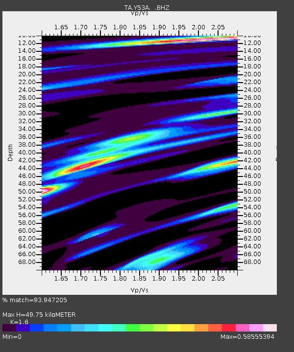
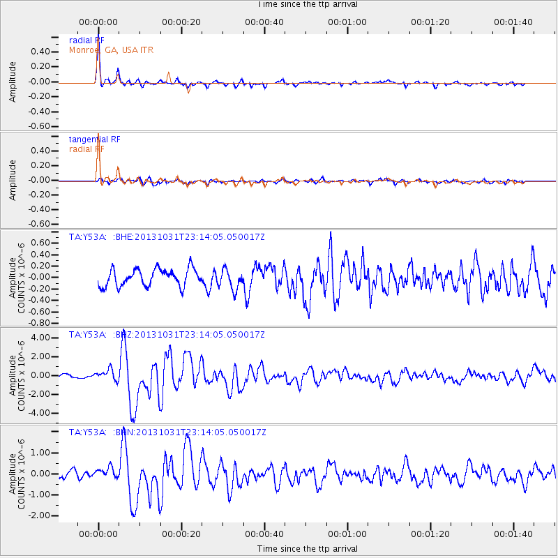
Y53A Monroe, GA, USA - Earthquake Result Viewer

Earthquake location: Near Coast Of Central Chile
Earthquake latitude/longitude: -30.3/-71.5
Earthquake time(UTC): 2013/10/31 (304) 23:03:59 GMT
Earthquake Depth: 27 km
Earthquake Magnitude: 6.6 MWW, 6.4 MWB, 6.5 MWC, 6.6 MWW, 6.6 MI
Earthquake Catalog/Contributor: NEIC PDE/NEIC COMCAT
Network: TA USArray Transportable Network (new EarthScope stations)
Station: Y53A Monroe, GA, USA
Lat/Lon: 33.86 N/83.58 W
Elevation: 234 m
Distance: 64.8 deg
Az: 348.92 deg
Baz: 168.478 deg
Ray Param: 0.058643855
Estimated Moho Depth: 49.75 km
Estimated Crust Vp/Vs: 1.60
Assumed Crust Vp: 6.565 km/s
Estimated Crust Vs: 4.103 km/s
Estimated Crust Poisson's Ratio: 0.18
Radial Match: 93.947205 %
Radial Bump: 316
Transverse Match: 80.06773 %
Transverse Bump: 400
SOD ConfigId: 626651
Insert Time: 2014-04-19 09:24:45.183 +0000
GWidth: 2.5
Max Bumps: 400
Tol: 0.001

Signal To Noise

ChannelStoNSTALTA
TA:Y53A: :BHZ:20131031T23:14:05.050017Z2.6853676.0775704E-72.2632177E-7
TA:Y53A: :BHN:20131031T23:14:05.050017Z1.59887082.8344766E-71.7727992E-7
TA:Y53A: :BHE:20131031T23:14:05.050017Z1.22001851.8119788E-71.4852058E-7
Arrivals
Ps4.8 SECOND
PpPs19 SECOND
PsPs/PpSs24 SECOND