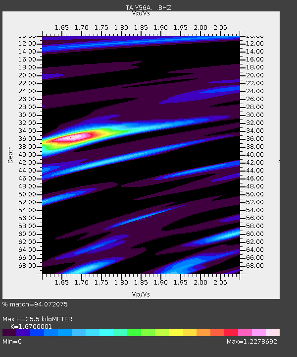
Y56A Pelion, SC, USA - Earthquake Result Viewer

Earthquake location: Near Coast Of Central Chile
Earthquake latitude/longitude: -30.3/-71.5
Earthquake time(UTC): 2013/10/31 (304) 23:03:59 GMT
Earthquake Depth: 27 km
Earthquake Magnitude: 6.6 MWW, 6.4 MWB, 6.5 MWC, 6.6 MWW, 6.6 MI
Earthquake Catalog/Contributor: NEIC PDE/NEIC COMCAT
Network: TA USArray Transportable Network (new EarthScope stations)
Station: Y56A Pelion, SC, USA
Lat/Lon: 33.79 N/81.30 W
Elevation: 154 m
Distance: 64.4 deg
Az: 350.973 deg
Baz: 170.621 deg
Ray Param: 0.058904137
Estimated Moho Depth: 35.5 km
Estimated Crust Vp/Vs: 1.67
Assumed Crust Vp: 6.565 km/s
Estimated Crust Vs: 3.931 km/s
Estimated Crust Poisson's Ratio: 0.22
Radial Match: 94.072075 %
Radial Bump: 400
Transverse Match: 73.65606 %
Transverse Bump: 400
SOD ConfigId: 626651
Insert Time: 2014-04-19 09:24:52.323 +0000
GWidth: 2.5
Max Bumps: 400
Tol: 0.001

Signal To Noise

ChannelStoNSTALTA
TA:Y56A: :BHZ:20131031T23:14:02.399993Z3.05212665.542809E-71.8160483E-7
TA:Y56A: :BHN:20131031T23:14:02.399993Z1.95875223.365173E-71.7180189E-7
TA:Y56A: :BHE:20131031T23:14:02.399993Z1.51004352.3279891E-71.5416703E-7
Arrivals
Ps3.8 SECOND
PpPs14 SECOND
PsPs/PpSs18 SECOND