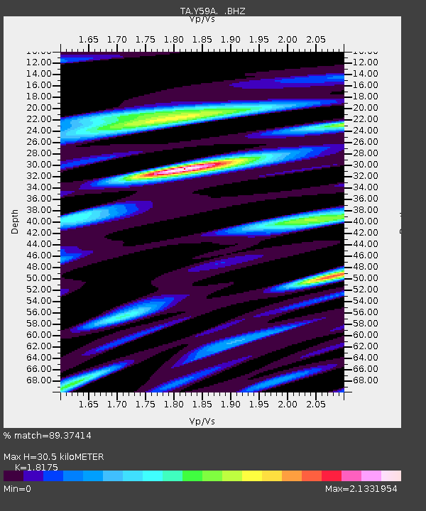
Y59A Loris, SC, USA - Earthquake Result Viewer
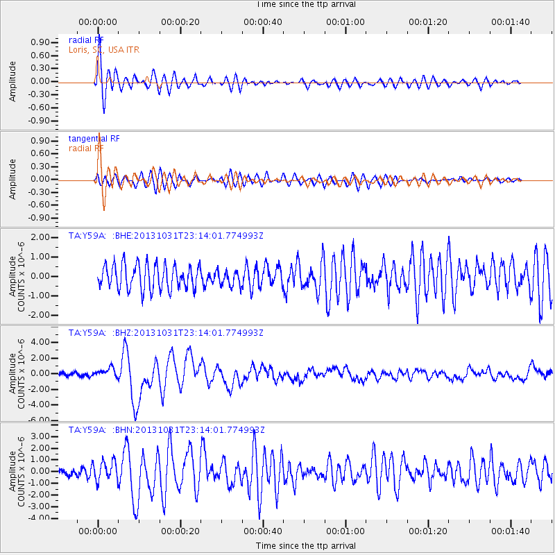
Earthquake location: Near Coast Of Central Chile
Earthquake latitude/longitude: -30.3/-71.5
Earthquake time(UTC): 2013/10/31 (304) 23:03:59 GMT
Earthquake Depth: 27 km
Earthquake Magnitude: 6.6 MWW, 6.4 MWB, 6.5 MWC, 6.6 MWW, 6.6 MI
Earthquake Catalog/Contributor: NEIC PDE/NEIC COMCAT
Network: TA USArray Transportable Network (new EarthScope stations)
Station: Y59A Loris, SC, USA
Lat/Lon: 33.99 N/78.87 W
Elevation: 2.0 m
Distance: 64.3 deg
Az: 353.224 deg
Baz: 172.945 deg
Ray Param: 0.05896431
Estimated Moho Depth: 30.5 km
Estimated Crust Vp/Vs: 1.82
Assumed Crust Vp: 6.24 km/s
Estimated Crust Vs: 3.433 km/s
Estimated Crust Poisson's Ratio: 0.28
Radial Match: 89.37414 %
Radial Bump: 400
Transverse Match: 67.32133 %
Transverse Bump: 400
SOD ConfigId: 626651
Insert Time: 2014-04-19 09:24:59.403 +0000
GWidth: 2.5
Max Bumps: 400
Tol: 0.001

Signal To Noise

ChannelStoNSTALTA
TA:Y59A: :BHZ:20131031T23:14:01.774993Z2.9190996.2965296E-72.1570112E-7
TA:Y59A: :BHN:20131031T23:14:01.774993Z2.0834258.1603935E-73.9168165E-7
TA:Y59A: :BHE:20131031T23:14:01.774993Z0.621165343.84129E-76.184006E-7
Arrivals
Ps4.2 SECOND
PpPs13 SECOND
PsPs/PpSs17 SECOND