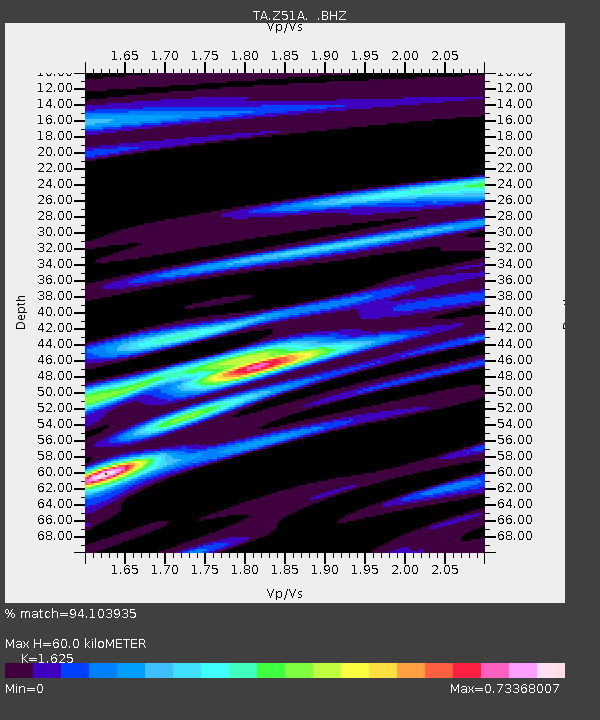
Z51A Franklin, GA, USA - Earthquake Result Viewer

Earthquake location: Near Coast Of Central Chile
Earthquake latitude/longitude: -30.3/-71.5
Earthquake time(UTC): 2013/10/31 (304) 23:03:59 GMT
Earthquake Depth: 27 km
Earthquake Magnitude: 6.6 MWW, 6.4 MWB, 6.5 MWC, 6.6 MWW, 6.6 MI
Earthquake Catalog/Contributor: NEIC PDE/NEIC COMCAT
Network: TA USArray Transportable Network (new EarthScope stations)
Station: Z51A Franklin, GA, USA
Lat/Lon: 33.32 N/85.17 W
Elevation: 249 m
Distance: 64.6 deg
Az: 347.358 deg
Baz: 166.934 deg
Ray Param: 0.058799263
Estimated Moho Depth: 60.0 km
Estimated Crust Vp/Vs: 1.62
Assumed Crust Vp: 6.719 km/s
Estimated Crust Vs: 4.135 km/s
Estimated Crust Poisson's Ratio: 0.20
Radial Match: 94.103935 %
Radial Bump: 382
Transverse Match: 74.47451 %
Transverse Bump: 400
SOD ConfigId: 626651
Insert Time: 2014-04-19 09:25:06.646 +0000
GWidth: 2.5
Max Bumps: 400
Tol: 0.001

Signal To Noise

ChannelStoNSTALTA
TA:Z51A: :BHZ:20131031T23:14:03.475005Z4.3681826.0216564E-71.3785268E-7
TA:Z51A: :BHN:20131031T23:14:03.475005Z2.75973183.3457553E-71.212348E-7
TA:Z51A: :BHE:20131031T23:14:03.475005Z1.34237781.5627484E-71.1641643E-7
Arrivals
Ps5.9 SECOND
PpPs22 SECOND
PsPs/PpSs28 SECOND