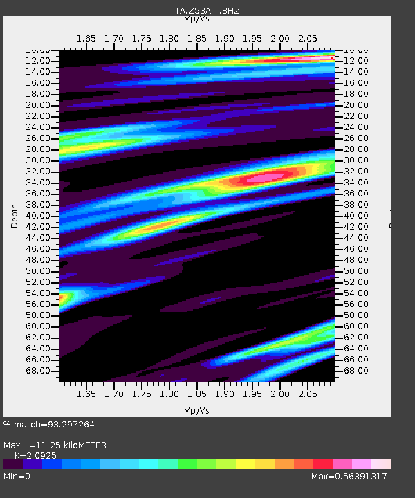
Z53A Monticello, GA, USA - Earthquake Result Viewer

Earthquake location: Near Coast Of Central Chile
Earthquake latitude/longitude: -30.3/-71.5
Earthquake time(UTC): 2013/10/31 (304) 23:03:59 GMT
Earthquake Depth: 27 km
Earthquake Magnitude: 6.6 MWW, 6.4 MWB, 6.5 MWC, 6.6 MWW, 6.6 MI
Earthquake Catalog/Contributor: NEIC PDE/NEIC COMCAT
Network: TA USArray Transportable Network (new EarthScope stations)
Station: Z53A Monticello, GA, USA
Lat/Lon: 33.28 N/83.57 W
Elevation: 144 m
Distance: 64.2 deg
Az: 348.804 deg
Baz: 168.435 deg
Ray Param: 0.059005264
Estimated Moho Depth: 11.25 km
Estimated Crust Vp/Vs: 2.09
Assumed Crust Vp: 6.565 km/s
Estimated Crust Vs: 3.137 km/s
Estimated Crust Poisson's Ratio: 0.35
Radial Match: 93.297264 %
Radial Bump: 317
Transverse Match: 72.86511 %
Transverse Bump: 400
SOD ConfigId: 626651
Insert Time: 2014-04-19 09:25:12.254 +0000
GWidth: 2.5
Max Bumps: 400
Tol: 0.001

Signal To Noise

ChannelStoNSTALTA
TA:Z53A: :BHZ:20131031T23:14:01.375029Z5.30433276.212399E-71.17119335E-7
TA:Z53A: :BHN:20131031T23:14:01.375029Z2.39516142.6347516E-71.10003086E-7
TA:Z53A: :BHE:20131031T23:14:01.375029Z1.42791271.7656227E-71.2365061E-7
Arrivals
Ps1.9 SECOND
PpPs5.1 SECOND
PsPs/PpSs7.0 SECOND