ACSO Alum Creek State Park, Ohio, USA - Earthquake Result Viewer
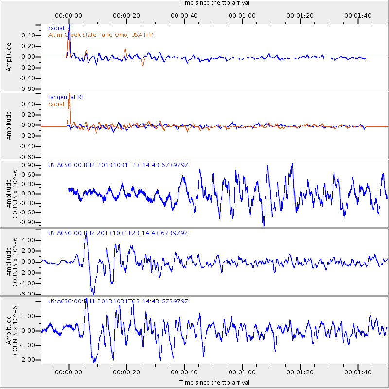
Earthquake location: Near Coast Of Central Chile
Earthquake latitude/longitude: -30.3/-71.5
Earthquake time(UTC): 2013/10/31 (304) 23:03:59 GMT
Earthquake Depth: 27 km
Earthquake Magnitude: 6.6 MWW, 6.4 MWB, 6.5 MWC, 6.6 MWW, 6.6 MI
Earthquake Catalog/Contributor: NEIC PDE/NEIC COMCAT
Network: US United States National Seismic Network
Station: ACSO Alum Creek State Park, Ohio, USA
Lat/Lon: 40.23 N/82.98 W
Elevation: 288 m
Distance: 71.0 deg
Az: 350.74 deg
Baz: 169.526 deg
Ray Param: 0.054594826
Estimated Moho Depth: 15.25 km
Estimated Crust Vp/Vs: 1.68
Assumed Crust Vp: 6.498 km/s
Estimated Crust Vs: 3.862 km/s
Estimated Crust Poisson's Ratio: 0.23
Radial Match: 94.405174 %
Radial Bump: 295
Transverse Match: 75.87848 %
Transverse Bump: 400
SOD ConfigId: 626651
Insert Time: 2014-04-19 09:25:39.764 +0000
GWidth: 2.5
Max Bumps: 400
Tol: 0.001

Signal To Noise

ChannelStoNSTALTA
US:ACSO:00:BHZ:20131031T23:14:43.673979Z3.53689676.124236E-71.7315281E-7
US:ACSO:00:BH1:20131031T23:14:43.673979Z1.79620643.671855E-72.0442278E-7
US:ACSO:00:BH2:20131031T23:14:43.673979Z1.73416731.9538923E-71.1267035E-7
Arrivals
Ps1.7 SECOND
PpPs6.1 SECOND
PsPs/PpSs7.7 SECOND