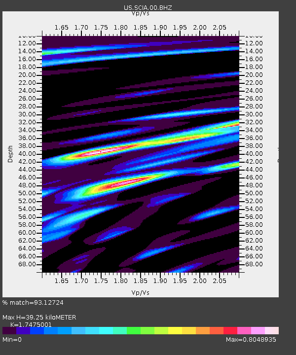
SCIA State Center, Iowa, USA - Earthquake Result Viewer

Earthquake location: Near Coast Of Central Chile
Earthquake latitude/longitude: -30.3/-71.5
Earthquake time(UTC): 2013/10/31 (304) 23:03:59 GMT
Earthquake Depth: 27 km
Earthquake Magnitude: 6.6 MWW, 6.4 MWB, 6.5 MWC, 6.6 MWW, 6.6 MI
Earthquake Catalog/Contributor: NEIC PDE/NEIC COMCAT
Network: US United States National Seismic Network
Station: SCIA State Center, Iowa, USA
Lat/Lon: 41.91 N/93.22 W
Elevation: 312 m
Distance: 74.6 deg
Az: 343.368 deg
Baz: 160.63 deg
Ray Param: 0.052205067
Estimated Moho Depth: 39.25 km
Estimated Crust Vp/Vs: 1.75
Assumed Crust Vp: 6.498 km/s
Estimated Crust Vs: 3.718 km/s
Estimated Crust Poisson's Ratio: 0.26
Radial Match: 93.12724 %
Radial Bump: 400
Transverse Match: 86.25579 %
Transverse Bump: 400
SOD ConfigId: 626651
Insert Time: 2014-04-19 09:27:21.290 +0000
GWidth: 2.5
Max Bumps: 400
Tol: 0.001

Signal To Noise

ChannelStoNSTALTA
US:SCIA:00:BHZ:20131031T23:15:05.024993Z3.73579818.024295E-72.1479465E-7
US:SCIA:00:BH1:20131031T23:15:05.024993Z1.74398953.3029684E-71.8939154E-7
US:SCIA:00:BH2:20131031T23:15:05.024993Z1.34320622.4972425E-71.8591655E-7
Arrivals
Ps4.7 SECOND
PpPs16 SECOND
PsPs/PpSs21 SECOND