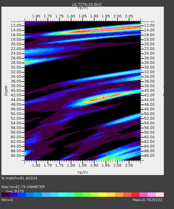
TZTN Tazewell, Tennessee, USA - Earthquake Result Viewer

Earthquake location: Near Coast Of Central Chile
Earthquake latitude/longitude: -30.3/-71.5
Earthquake time(UTC): 2013/10/31 (304) 23:03:59 GMT
Earthquake Depth: 27 km
Earthquake Magnitude: 6.6 MWW, 6.4 MWB, 6.5 MWC, 6.6 MWW, 6.6 MI
Earthquake Catalog/Contributor: NEIC PDE/NEIC COMCAT
Network: US United States National Seismic Network
Station: TZTN Tazewell, Tennessee, USA
Lat/Lon: 36.54 N/83.55 W
Elevation: 394 m
Distance: 67.4 deg
Az: 349.53 deg
Baz: 168.745 deg
Ray Param: 0.05692015
Estimated Moho Depth: 42.75 km
Estimated Crust Vp/Vs: 1.94
Assumed Crust Vp: 6.476 km/s
Estimated Crust Vs: 3.342 km/s
Estimated Crust Poisson's Ratio: 0.32
Radial Match: 91.60024 %
Radial Bump: 400
Transverse Match: 75.53716 %
Transverse Bump: 400
SOD ConfigId: 626651
Insert Time: 2014-04-19 09:27:28.821 +0000
GWidth: 2.5
Max Bumps: 400
Tol: 0.001

Signal To Noise

ChannelStoNSTALTA
US:TZTN:00:BHZ:20131031T23:14:21.849028Z5.30704836.959695E-71.3114061E-7
US:TZTN:00:BH1:20131031T23:14:21.849028Z1.8479312.3608388E-71.2775578E-7
US:TZTN:00:BH2:20131031T23:14:21.849028Z1.30777811.8257904E-71.3961011E-7
Arrivals
Ps6.4 SECOND
PpPs19 SECOND
PsPs/PpSs25 SECOND