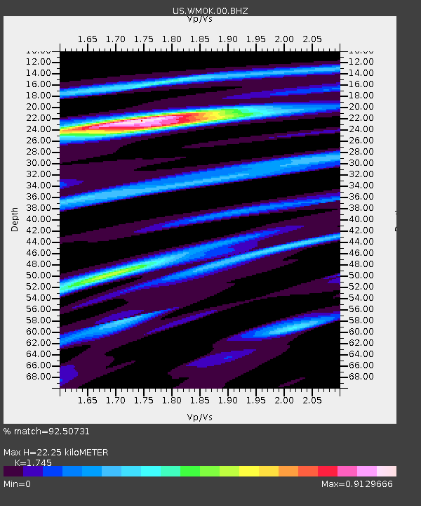
WMOK Wichita Mountains, Oklahoma, USA - Earthquake Result Viewer

Earthquake location: Near Coast Of Central Chile
Earthquake latitude/longitude: -30.3/-71.5
Earthquake time(UTC): 2013/10/31 (304) 23:03:59 GMT
Earthquake Depth: 27 km
Earthquake Magnitude: 6.6 MWW, 6.4 MWB, 6.5 MWC, 6.6 MWW, 6.6 MI
Earthquake Catalog/Contributor: NEIC PDE/NEIC COMCAT
Network: US United States National Seismic Network
Station: WMOK Wichita Mountains, Oklahoma, USA
Lat/Lon: 34.74 N/98.78 W
Elevation: 486 m
Distance: 69.6 deg
Az: 336.269 deg
Baz: 154.997 deg
Ray Param: 0.05550097
Estimated Moho Depth: 22.25 km
Estimated Crust Vp/Vs: 1.75
Assumed Crust Vp: 6.315 km/s
Estimated Crust Vs: 3.619 km/s
Estimated Crust Poisson's Ratio: 0.26
Radial Match: 92.50731 %
Radial Bump: 397
Transverse Match: 81.442566 %
Transverse Bump: 400
SOD ConfigId: 626651
Insert Time: 2014-04-19 09:27:32.799 +0000
GWidth: 2.5
Max Bumps: 400
Tol: 0.001

Signal To Noise

ChannelStoNSTALTA
US:WMOK:00:BHZ:20131031T23:14:35.32498Z4.4460234.1445898E-79.322016E-8
US:WMOK:00:BH1:20131031T23:14:35.32498Z1.89924171.9289836E-71.0156599E-7
US:WMOK:00:BH2:20131031T23:14:35.32498Z1.79262411.4692499E-78.196084E-8
Arrivals
Ps2.7 SECOND
PpPs9.3 SECOND
PsPs/PpSs12 SECOND