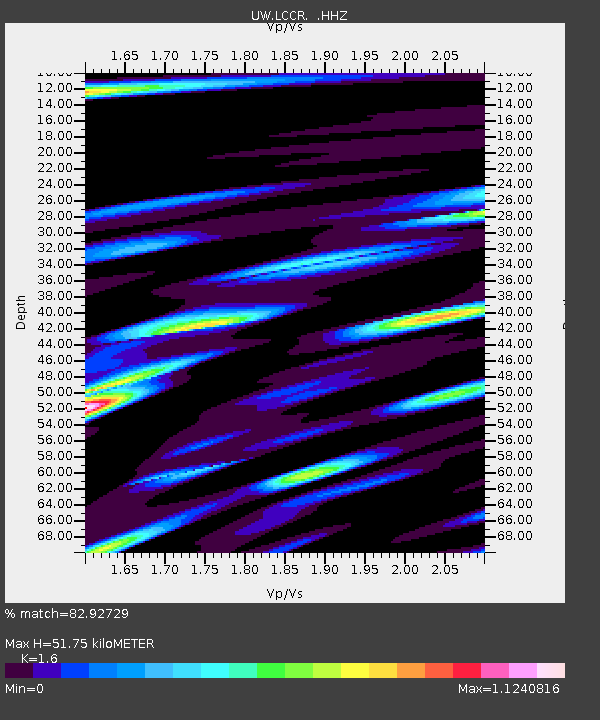
LCCR Mulino, OR, USA - Earthquake Result Viewer

Earthquake location: Near Coast Of Central Chile
Earthquake latitude/longitude: -30.3/-71.5
Earthquake time(UTC): 2013/10/31 (304) 23:03:59 GMT
Earthquake Depth: 27 km
Earthquake Magnitude: 6.6 MWW, 6.4 MWB, 6.5 MWC, 6.6 MWW, 6.6 MI
Earthquake Catalog/Contributor: NEIC PDE/NEIC COMCAT
Network: UW Pacific Northwest Regional Seismic Network
Station: LCCR Mulino, OR, USA
Lat/Lon: 45.21 N/122.48 W
Elevation: 273 m
Distance: 88.3 deg
Az: 326.68 deg
Baz: 137.772 deg
Ray Param: 0.042680744
Estimated Moho Depth: 51.75 km
Estimated Crust Vp/Vs: 1.60
Assumed Crust Vp: 6.566 km/s
Estimated Crust Vs: 4.104 km/s
Estimated Crust Poisson's Ratio: 0.18
Radial Match: 82.92729 %
Radial Bump: 400
Transverse Match: 72.44559 %
Transverse Bump: 400
SOD ConfigId: 626651
Insert Time: 2014-04-19 09:28:53.135 +0000
GWidth: 2.5
Max Bumps: 400
Tol: 0.001

Signal To Noise

ChannelStoNSTALTA
UW:LCCR: :HHZ:20131031T23:16:17.188018Z3.11923484.837501E-71.5508616E-7
UW:LCCR: :HHN:20131031T23:16:17.188018Z1.27653172.928498E-72.2941052E-7
UW:LCCR: :HHE:20131031T23:16:17.188018Z1.22854244.0118297E-73.26552E-7
Arrivals
Ps4.8 SECOND
PpPs20 SECOND
PsPs/PpSs25 SECOND