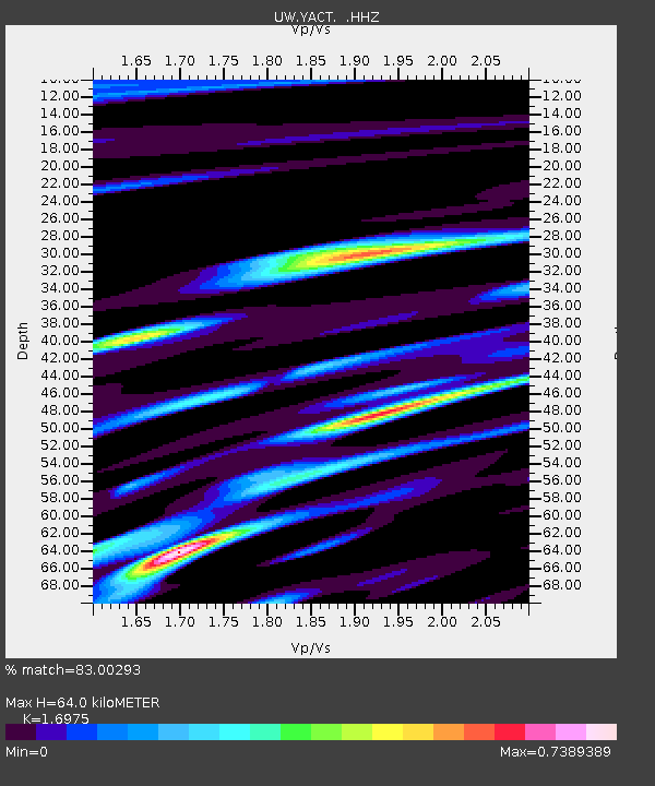
YACT Amboy, WA, USA - Earthquake Result Viewer
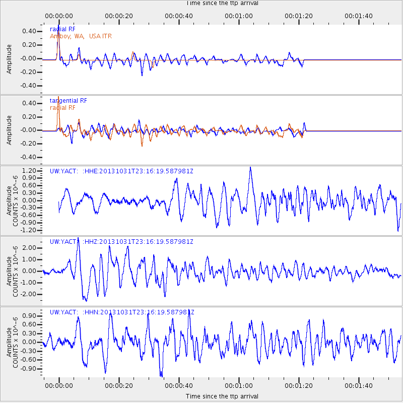
Earthquake location: Near Coast Of Central Chile
Earthquake latitude/longitude: -30.3/-71.5
Earthquake time(UTC): 2013/10/31 (304) 23:03:59 GMT
Earthquake Depth: 27 km
Earthquake Magnitude: 6.6 MWW, 6.4 MWB, 6.5 MWC, 6.6 MWW, 6.6 MI
Earthquake Catalog/Contributor: NEIC PDE/NEIC COMCAT
Network: UW Pacific Northwest Regional Seismic Network
Station: YACT Amboy, WA, USA
Lat/Lon: 45.93 N/122.42 W
Elevation: 211 m
Distance: 88.8 deg
Az: 327.199 deg
Baz: 137.828 deg
Ray Param: 0.04230049
Estimated Moho Depth: 64.0 km
Estimated Crust Vp/Vs: 1.70
Assumed Crust Vp: 6.566 km/s
Estimated Crust Vs: 3.868 km/s
Estimated Crust Poisson's Ratio: 0.23
Radial Match: 83.00293 %
Radial Bump: 400
Transverse Match: 79.647095 %
Transverse Bump: 400
SOD ConfigId: 626651
Insert Time: 2014-04-19 09:29:14.773 +0000
GWidth: 2.5
Max Bumps: 400
Tol: 0.001

Signal To Noise

ChannelStoNSTALTA
UW:YACT: :HHZ:20131031T23:16:19.587981Z2.8324744.1099022E-71.4509939E-7
UW:YACT: :HHN:20131031T23:16:19.587981Z0.61254788.2057916E-81.3396165E-7
UW:YACT: :HHE:20131031T23:16:19.587981Z0.66781831.5303586E-72.291579E-7
Arrivals
Ps7.0 SECOND
PpPs26 SECOND
PsPs/PpSs33 SECOND