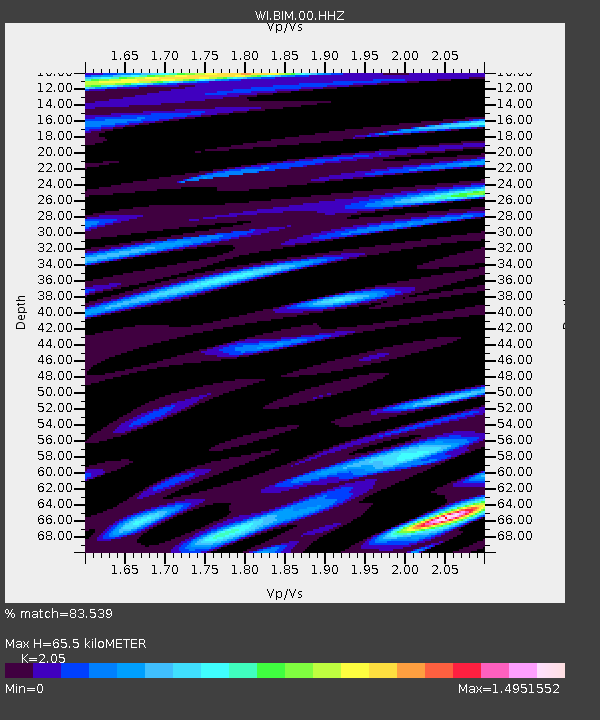
BIM Morne Bigot, Anses d'Arlets, Martinique - Earthquake Result Viewer
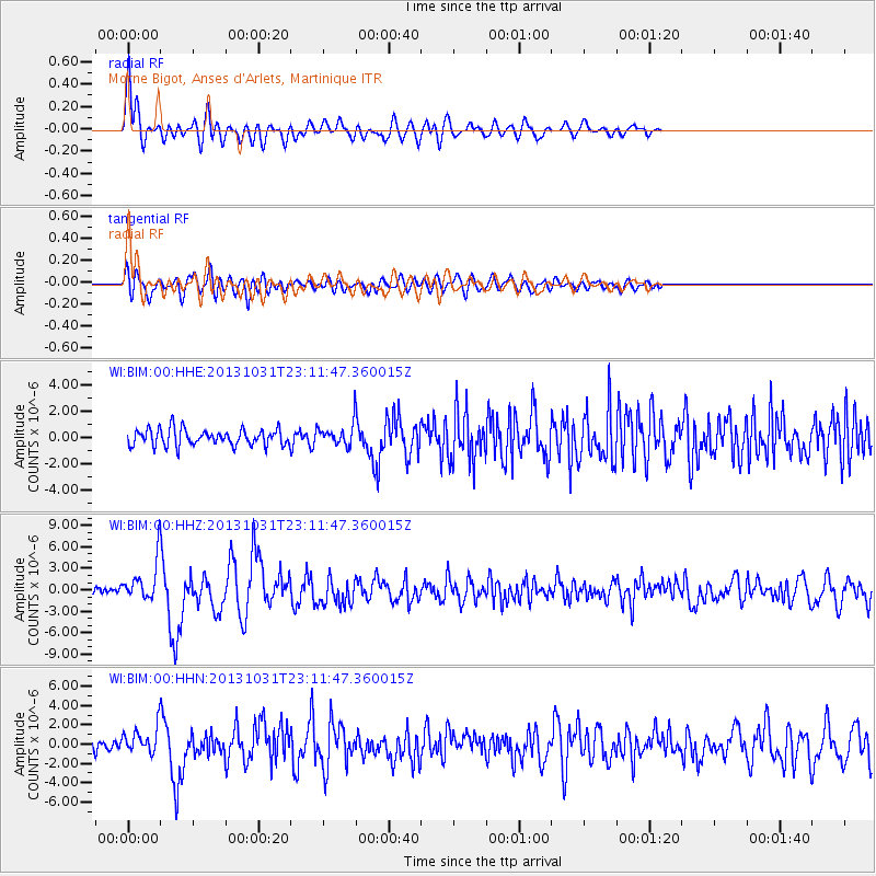
Earthquake location: Near Coast Of Central Chile
Earthquake latitude/longitude: -30.3/-71.5
Earthquake time(UTC): 2013/10/31 (304) 23:03:59 GMT
Earthquake Depth: 27 km
Earthquake Magnitude: 6.6 MWW, 6.4 MWB, 6.5 MWC, 6.6 MWW, 6.6 MI
Earthquake Catalog/Contributor: NEIC PDE/NEIC COMCAT
Network: WI West Indies IPGP Network
Station: BIM Morne Bigot, Anses d'Arlets, Martinique
Lat/Lon: 14.52 N/61.07 W
Elevation: 391 m
Distance: 45.7 deg
Az: 14.222 deg
Baz: 192.674 deg
Ray Param: 0.07107323
Estimated Moho Depth: 65.5 km
Estimated Crust Vp/Vs: 2.05
Assumed Crust Vp: 5.88 km/s
Estimated Crust Vs: 2.868 km/s
Estimated Crust Poisson's Ratio: 0.34
Radial Match: 83.539 %
Radial Bump: 400
Transverse Match: 65.634636 %
Transverse Bump: 400
SOD ConfigId: 626651
Insert Time: 2014-04-19 09:29:20.212 +0000
GWidth: 2.5
Max Bumps: 400
Tol: 0.001

Signal To Noise

ChannelStoNSTALTA
WI:BIM:00:HHZ:20131031T23:11:47.360015Z5.69911862.576087E-64.5201494E-7
WI:BIM:00:HHN:20131031T23:11:47.360015Z2.19958661.3083753E-65.948278E-7
WI:BIM:00:HHE:20131031T23:11:47.360015Z1.234257.6458946E-76.19477E-7
Arrivals
Ps12 SECOND
PpPs32 SECOND
PsPs/PpSs45 SECOND