You are here: Home > Network List > WY - Yellowstone Wyoming Seismic Network Stations List
> Station YHH Holmes Hill, YNP, WY, USA > Earthquake Result Viewer
YHH Holmes Hill, YNP, WY, USA - Earthquake Result Viewer
| Earthquake location: |
Near Coast Of Central Chile |
| Earthquake latitude/longitude: |
-30.3/-71.5 |
| Earthquake time(UTC): |
2013/10/31 (304) 23:03:59 GMT |
| Earthquake Depth: |
27 km |
| Earthquake Magnitude: |
6.6 MWW, 6.4 MWB, 6.5 MWC, 6.6 MWW, 6.6 MI |
| Earthquake Catalog/Contributor: |
NEIC PDE/NEIC COMCAT |
|
| Network: |
WY Yellowstone Wyoming Seismic Network |
| Station: |
YHH Holmes Hill, YNP, WY, USA |
| Lat/Lon: |
44.79 N/110.85 W |
| Elevation: |
2717 m |
|
| Distance: |
82.9 deg |
| Az: |
332.948 deg |
| Baz: |
146.466 deg |
| Ray Param: |
0.046552107 |
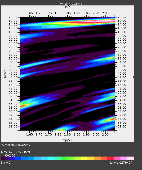
| Estimated Moho Depth: |
11.75 km |
| Estimated Crust Vp/Vs: |
2.02 |
| Assumed Crust Vp: |
6.35 km/s |
| Estimated Crust Vs: |
3.144 km/s |
| Estimated Crust Poisson's Ratio: |
0.34 |
|
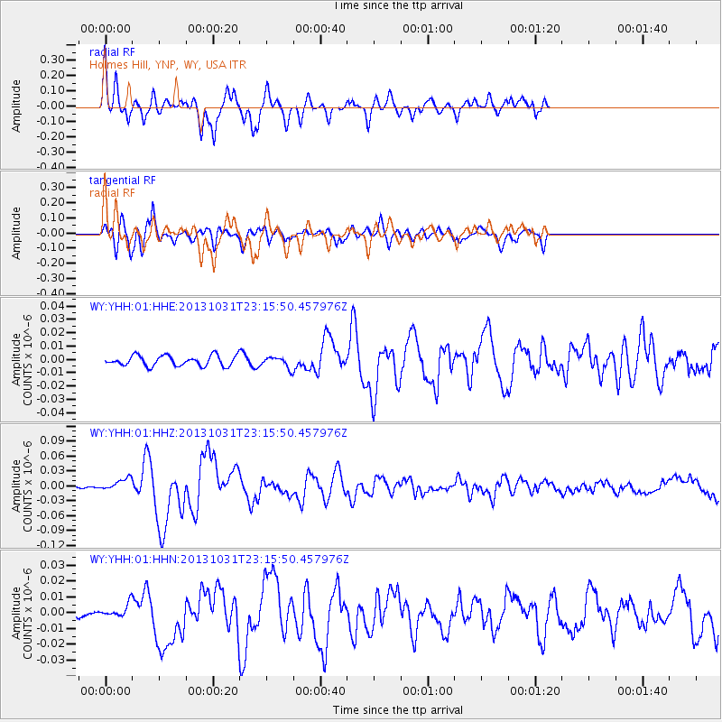
| Radial Match: |
85.32257 % |
| Radial Bump: |
400 |
| Transverse Match: |
77.53653 % |
| Transverse Bump: |
400 |
| SOD ConfigId: |
626651 |
| Insert Time: |
2014-04-19 09:30:37.319 +0000 |
| GWidth: |
2.5 |
| Max Bumps: |
400 |
| Tol: |
0.001 |
|
Signal To Noise
| Channel | StoN | STA | LTA |
| WY:YHH:01:HHZ:20131031T23:15:50.457976Z | 4.3654127 | 1.246262E-8 | 2.8548548E-9 |
| WY:YHH:01:HHN:20131031T23:15:50.457976Z | 0.9142757 | 4.336647E-9 | 4.7432596E-9 |
| WY:YHH:01:HHE:20131031T23:15:50.457976Z | 1.0457906 | 4.0350505E-9 | 3.8583736E-9 |
| Arrivals |
| Ps | 1.9 SECOND |
| PpPs | 5.5 SECOND |
| PsPs/PpSs | 7.4 SECOND |


