You are here: Home > Network List > PE - Penn State Network Stations List
> Station PAGS PA Geological Survey > Earthquake Result Viewer
PAGS PA Geological Survey - Earthquake Result Viewer
*The percent match for this event was below the threshold and hence no stack was calculated.
| Earthquake location: |
Easter Island Region |
| Earthquake latitude/longitude: |
-23.6/-112.6 |
| Earthquake time(UTC): |
2013/11/02 (306) 15:52:46 GMT |
| Earthquake Depth: |
10 km |
| Earthquake Magnitude: |
6.0 MWW, 5.9 MWB, 6.0 MWW, 6.0 MWC, 6.1 MWC |
| Earthquake Catalog/Contributor: |
NEIC PDE/NEIC COMCAT |
|
| Network: |
PE Penn State Network |
| Station: |
PAGS PA Geological Survey |
| Lat/Lon: |
40.23 N/76.72 W |
| Elevation: |
120 m |
|
| Distance: |
71.8 deg |
| Az: |
28.184 deg |
| Baz: |
214.454 deg |
| Ray Param: |
$rayparam |
*The percent match for this event was below the threshold and hence was not used in the summary stack. |
|
| Radial Match: |
58.20139 % |
| Radial Bump: |
400 |
| Transverse Match: |
59.831665 % |
| Transverse Bump: |
400 |
| SOD ConfigId: |
626651 |
| Insert Time: |
2014-04-19 09:50:42.351 +0000 |
| GWidth: |
2.5 |
| Max Bumps: |
400 |
| Tol: |
0.001 |
|
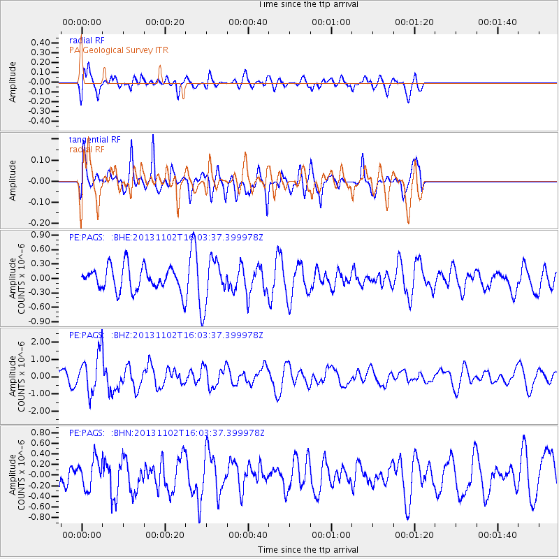
Signal To Noise
| Channel | StoN | STA | LTA |
| PE:PAGS: :BHZ:20131102T16:03:37.399978Z | 2.4658554 | 1.117591E-6 | 4.5322648E-7 |
| PE:PAGS: :BHN:20131102T16:03:37.399978Z | 0.5396311 | 2.6717473E-7 | 4.9510624E-7 |
| PE:PAGS: :BHE:20131102T16:03:37.399978Z | 1.8868166 | 4.6292163E-7 | 2.4534532E-7 |
| Arrivals |
| Ps | |
| PpPs | |
| PsPs/PpSs | |


