You are here: Home > Network List > TA - USArray Transportable Network (new EarthScope stations) Stations List
> Station F42A Maple Grove Farm, Niagara, WI, USA > Earthquake Result Viewer
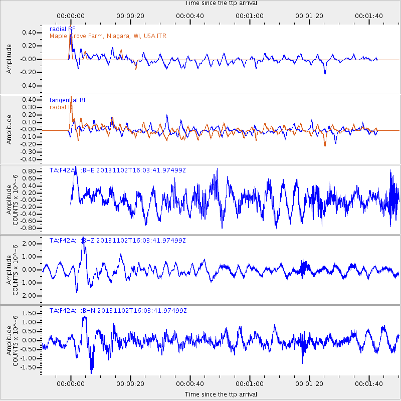
F42A Maple Grove Farm, Niagara, WI, USA - Earthquake Result Viewer
*The percent match for this event was below the threshold and hence no stack was calculated.
| Earthquake location: |
Easter Island Region |
| Earthquake latitude/longitude: |
-23.6/-112.6 |
| Earthquake time(UTC): |
2013/11/02 (306) 15:52:46 GMT |
| Earthquake Depth: |
10 km |
| Earthquake Magnitude: |
6.0 MWW, 5.9 MWB, 6.0 MWW, 6.0 MWC, 6.1 MWC |
| Earthquake Catalog/Contributor: |
NEIC PDE/NEIC COMCAT |
|
| Network: |
TA USArray Transportable Network (new EarthScope stations) |
| Station: |
F42A Maple Grove Farm, Niagara, WI, USA |
| Lat/Lon: |
45.76 N/88.13 W |
| Elevation: |
358 m |
|
| Distance: |
72.6 deg |
| Az: |
17.689 deg |
| Baz: |
203.456 deg |
| Ray Param: |
$rayparam |
*The percent match for this event was below the threshold and hence was not used in the summary stack. |
|
| Radial Match: |
56.895027 % |
| Radial Bump: |
400 |
| Transverse Match: |
57.174778 % |
| Transverse Bump: |
400 |
| SOD ConfigId: |
626651 |
| Insert Time: |
2014-04-19 09:57:09.904 +0000 |
| GWidth: |
2.5 |
| Max Bumps: |
400 |
| Tol: |
0.001 |
|
Signal To Noise
| Channel | StoN | STA | LTA |
| TA:F42A: :BHZ:20131102T16:03:41.97499Z | 4.787969 | 1.1034377E-6 | 2.304605E-7 |
| TA:F42A: :BHN:20131102T16:03:41.97499Z | 2.8777044 | 6.4121593E-7 | 2.2282202E-7 |
| TA:F42A: :BHE:20131102T16:03:41.97499Z | 1.2909001 | 3.3164014E-7 | 2.569061E-7 |
| Arrivals |
| Ps | |
| PpPs | |
| PsPs/PpSs | |


