You are here: Home > Network List > TA - USArray Transportable Network (new EarthScope stations) Stations List
> Station G47A Hillman, MI, USA > Earthquake Result Viewer
G47A Hillman, MI, USA - Earthquake Result Viewer

| Earthquake location: |
Easter Island Region |
| Earthquake latitude/longitude: |
-23.6/-112.6 |
| Earthquake time(UTC): |
2013/11/02 (306) 15:52:46 GMT |
| Earthquake Depth: |
10 km |
| Earthquake Magnitude: |
6.0 MWW, 5.9 MWB, 6.0 MWW, 6.0 MWC, 6.1 MWC |
| Earthquake Catalog/Contributor: |
NEIC PDE/NEIC COMCAT |
|
| Network: |
TA USArray Transportable Network (new EarthScope stations) |
| Station: |
G47A Hillman, MI, USA |
| Lat/Lon: |
45.17 N/83.86 W |
| Elevation: |
239 m |
|
| Distance: |
73.3 deg |
| Az: |
20.797 deg |
| Baz: |
207.409 deg |
| Ray Param: |
0.05308097 |
| Estimated Moho Depth: |
35.5 km |
| Estimated Crust Vp/Vs: |
1.86 |
| Assumed Crust Vp: |
6.483 km/s |
| Estimated Crust Vs: |
3.485 km/s |
| Estimated Crust Poisson's Ratio: |
0.30 |
|
| Radial Match: |
80.741295 % |
| Radial Bump: |
400 |
| Transverse Match: |
69.50487 % |
| Transverse Bump: |
400 |
| SOD ConfigId: |
626651 |
| Insert Time: |
2014-04-19 09:58:00.727 +0000 |
| GWidth: |
2.5 |
| Max Bumps: |
400 |
| Tol: |
0.001 |
|
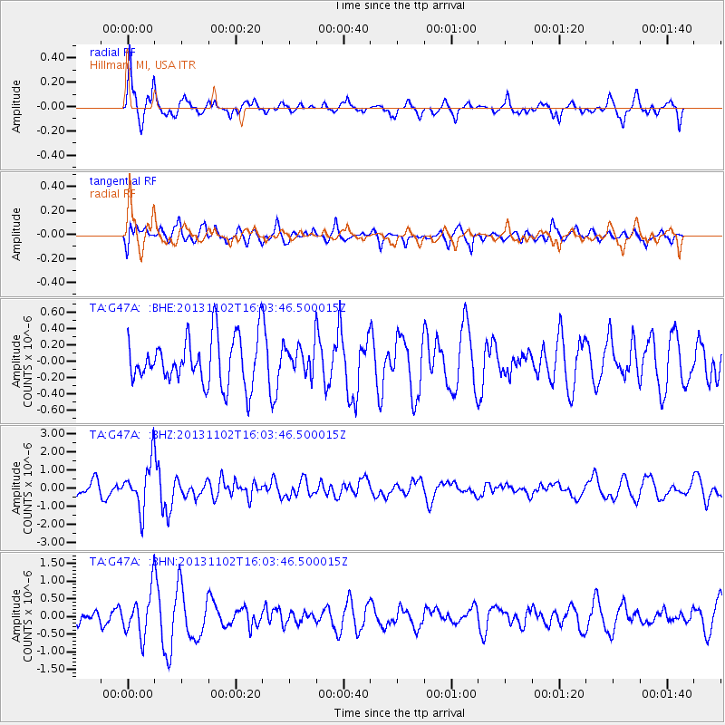
Signal To Noise
| Channel | StoN | STA | LTA |
| TA:G47A: :BHZ:20131102T16:03:46.500015Z | 4.2150273 | 1.3216702E-6 | 3.135615E-7 |
| TA:G47A: :BHN:20131102T16:03:46.500015Z | 2.0087192 | 6.376151E-7 | 3.174237E-7 |
| TA:G47A: :BHE:20131102T16:03:46.500015Z | 0.58841985 | 1.712408E-7 | 2.9101807E-7 |
| Arrivals |
| Ps | 4.9 SECOND |
| PpPs | 15 SECOND |
| PsPs/PpSs | 20 SECOND |


