You are here: Home > Network List > TA - USArray Transportable Network (new EarthScope stations) Stations List
> Station K62A Royalston, MA, USA > Earthquake Result Viewer
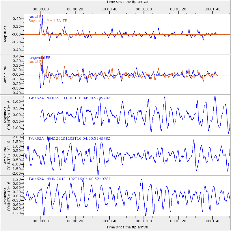
K62A Royalston, MA, USA - Earthquake Result Viewer
*The percent match for this event was below the threshold and hence no stack was calculated.
| Earthquake location: |
Easter Island Region |
| Earthquake latitude/longitude: |
-23.6/-112.6 |
| Earthquake time(UTC): |
2013/11/02 (306) 15:52:46 GMT |
| Earthquake Depth: |
10 km |
| Earthquake Magnitude: |
6.0 MWW, 5.9 MWB, 6.0 MWW, 6.0 MWC, 6.1 MWC |
| Earthquake Catalog/Contributor: |
NEIC PDE/NEIC COMCAT |
|
| Network: |
TA USArray Transportable Network (new EarthScope stations) |
| Station: |
K62A Royalston, MA, USA |
| Lat/Lon: |
42.67 N/72.23 W |
| Elevation: |
289 m |
|
| Distance: |
75.7 deg |
| Az: |
29.527 deg |
| Baz: |
217.791 deg |
| Ray Param: |
$rayparam |
*The percent match for this event was below the threshold and hence was not used in the summary stack. |
|
| Radial Match: |
65.75785 % |
| Radial Bump: |
398 |
| Transverse Match: |
40.393852 % |
| Transverse Bump: |
358 |
| SOD ConfigId: |
626651 |
| Insert Time: |
2014-04-19 10:01:47.472 +0000 |
| GWidth: |
2.5 |
| Max Bumps: |
400 |
| Tol: |
0.001 |
|
Signal To Noise
| Channel | StoN | STA | LTA |
| TA:K62A: :BHZ:20131102T16:04:00.524978Z | 2.2749817 | 1.0150567E-6 | 4.4618236E-7 |
| TA:K62A: :BHN:20131102T16:04:00.524978Z | 1.6655946 | 6.817553E-7 | 4.093165E-7 |
| TA:K62A: :BHE:20131102T16:04:00.524978Z | 2.0257382 | 5.5087764E-7 | 2.719392E-7 |
| Arrivals |
| Ps | |
| PpPs | |
| PsPs/PpSs | |


