You are here: Home > Network List > II - Global Seismograph Network (GSN - IRIS/IDA) Stations List
> Station TLY Talaya, Russia > Earthquake Result Viewer
TLY Talaya, Russia - Earthquake Result Viewer
| Earthquake location: |
Santa Cruz Islands |
| Earthquake latitude/longitude: |
-12.6/166.7 |
| Earthquake time(UTC): |
1997/04/21 (111) 12:02:26 GMT |
| Earthquake Depth: |
33 km |
| Earthquake Magnitude: |
6.4 MB, 7.9 MS, 7.9 UNKNOWN, 7.8 MW |
| Earthquake Catalog/Contributor: |
WHDF/NEIC |
|
| Network: |
II Global Seismograph Network (GSN - IRIS/IDA) |
| Station: |
TLY Talaya, Russia |
| Lat/Lon: |
51.68 N/103.64 E |
| Elevation: |
579 m |
|
| Distance: |
83.9 deg |
| Az: |
326.078 deg |
| Baz: |
118.946 deg |
| Ray Param: |
0.04581431 |
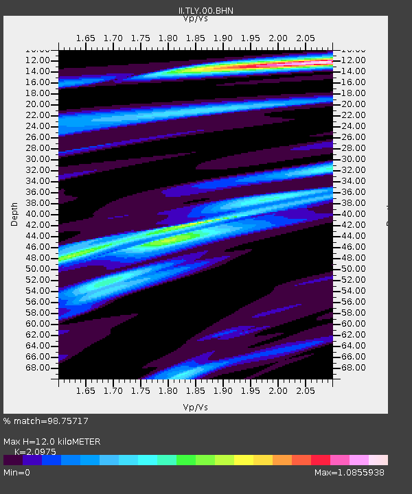
| Estimated Moho Depth: |
12.0 km |
| Estimated Crust Vp/Vs: |
2.10 |
| Assumed Crust Vp: |
6.419 km/s |
| Estimated Crust Vs: |
3.06 km/s |
| Estimated Crust Poisson's Ratio: |
0.35 |
|
| Radial Match: |
98.75717 % |
| Radial Bump: |
297 |
| Transverse Match: |
97.5549 % |
| Transverse Bump: |
400 |
| SOD ConfigId: |
4480 |
| Insert Time: |
2010-03-01 17:41:06.996 +0000 |
| GWidth: |
2.5 |
| Max Bumps: |
400 |
| Tol: |
0.001 |
|

Signal To Noise
| Channel | StoN | STA | LTA |
| II:TLY:00:BHN:19970421T12:14:21.722021Z | 36.442673 | 1.9200793E-6 | 5.2687664E-8 |
| II:TLY:00:BHE:19970421T12:14:21.722021Z | 11.636802 | 4.797365E-7 | 4.1225803E-8 |
| II:TLY:00:BHZ:19970421T12:14:21.722021Z | 8.977222 | 5.3175575E-7 | 5.9233884E-8 |
| Arrivals |
| Ps | 2.1 SECOND |
| PpPs | 5.7 SECOND |
| PsPs/PpSs | 7.8 SECOND |


