You are here: Home > Network List > TA - USArray Transportable Network (new EarthScope stations) Stations List
> Station M57A Sunshine Farm, Cogan Station, PA, USA > Earthquake Result Viewer
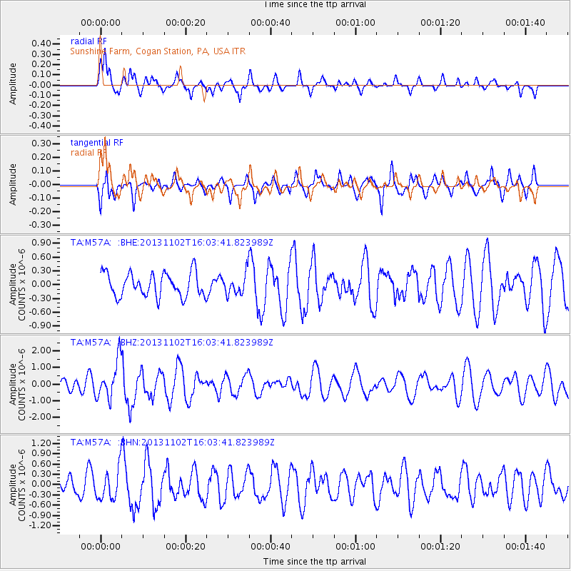
M57A Sunshine Farm, Cogan Station, PA, USA - Earthquake Result Viewer
*The percent match for this event was below the threshold and hence no stack was calculated.
| Earthquake location: |
Easter Island Region |
| Earthquake latitude/longitude: |
-23.6/-112.6 |
| Earthquake time(UTC): |
2013/11/02 (306) 15:52:46 GMT |
| Earthquake Depth: |
10 km |
| Earthquake Magnitude: |
6.0 MWW, 5.9 MWB, 6.0 MWW, 6.0 MWC, 6.1 MWC |
| Earthquake Catalog/Contributor: |
NEIC PDE/NEIC COMCAT |
|
| Network: |
TA USArray Transportable Network (new EarthScope stations) |
| Station: |
M57A Sunshine Farm, Cogan Station, PA, USA |
| Lat/Lon: |
41.34 N/77.13 W |
| Elevation: |
319 m |
|
| Distance: |
72.5 deg |
| Az: |
27.262 deg |
| Baz: |
213.908 deg |
| Ray Param: |
$rayparam |
*The percent match for this event was below the threshold and hence was not used in the summary stack. |
|
| Radial Match: |
74.240776 % |
| Radial Bump: |
400 |
| Transverse Match: |
65.1165 % |
| Transverse Bump: |
400 |
| SOD ConfigId: |
626651 |
| Insert Time: |
2014-04-19 10:03:23.426 +0000 |
| GWidth: |
2.5 |
| Max Bumps: |
400 |
| Tol: |
0.001 |
|
Signal To Noise
| Channel | StoN | STA | LTA |
| TA:M57A: :BHZ:20131102T16:03:41.823989Z | 2.5379303 | 1.1865577E-6 | 4.6752965E-7 |
| TA:M57A: :BHN:20131102T16:03:41.823989Z | 1.6281383 | 4.7094142E-7 | 2.892515E-7 |
| TA:M57A: :BHE:20131102T16:03:41.823989Z | 0.9297161 | 2.3848668E-7 | 2.565156E-7 |
| Arrivals |
| Ps | |
| PpPs | |
| PsPs/PpSs | |


