You are here: Home > Network List > TA - USArray Transportable Network (new EarthScope stations) Stations List
> Station V48A Smith Brothers Farm, Spring Hill, TN, USA > Earthquake Result Viewer
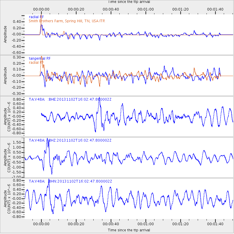
V48A Smith Brothers Farm, Spring Hill, TN, USA - Earthquake Result Viewer
*The percent match for this event was below the threshold and hence no stack was calculated.
| Earthquake location: |
Easter Island Region |
| Earthquake latitude/longitude: |
-23.6/-112.6 |
| Earthquake time(UTC): |
2013/11/02 (306) 15:52:46 GMT |
| Earthquake Depth: |
10 km |
| Earthquake Magnitude: |
6.0 MWW, 5.9 MWB, 6.0 MWW, 6.0 MWC, 6.1 MWC |
| Earthquake Catalog/Contributor: |
NEIC PDE/NEIC COMCAT |
|
| Network: |
TA USArray Transportable Network (new EarthScope stations) |
| Station: |
V48A Smith Brothers Farm, Spring Hill, TN, USA |
| Lat/Lon: |
35.74 N/86.82 W |
| Elevation: |
278 m |
|
| Distance: |
63.9 deg |
| Az: |
23.199 deg |
| Baz: |
206.364 deg |
| Ray Param: |
$rayparam |
*The percent match for this event was below the threshold and hence was not used in the summary stack. |
|
| Radial Match: |
65.30509 % |
| Radial Bump: |
400 |
| Transverse Match: |
68.85184 % |
| Transverse Bump: |
400 |
| SOD ConfigId: |
626651 |
| Insert Time: |
2014-04-19 10:09:25.671 +0000 |
| GWidth: |
2.5 |
| Max Bumps: |
400 |
| Tol: |
0.001 |
|
Signal To Noise
| Channel | StoN | STA | LTA |
| TA:V48A: :BHZ:20131102T16:02:47.800002Z | 4.850818 | 9.658543E-7 | 1.9911162E-7 |
| TA:V48A: :BHN:20131102T16:02:47.800002Z | 1.9499216 | 4.0154447E-7 | 2.0592852E-7 |
| TA:V48A: :BHE:20131102T16:02:47.800002Z | 4.0633416 | 4.6549812E-7 | 1.1456043E-7 |
| Arrivals |
| Ps | |
| PpPs | |
| PsPs/PpSs | |


