You are here: Home > Network List > TA - USArray Transportable Network (new EarthScope stations) Stations List
> Station Y12C Blythe, CA, USA > Earthquake Result Viewer
Y12C Blythe, CA, USA - Earthquake Result Viewer

| Earthquake location: |
Easter Island Region |
| Earthquake latitude/longitude: |
-23.6/-112.6 |
| Earthquake time(UTC): |
2013/11/02 (306) 15:52:46 GMT |
| Earthquake Depth: |
10 km |
| Earthquake Magnitude: |
6.0 MWW, 5.9 MWB, 6.0 MWW, 6.0 MWC, 6.1 MWC |
| Earthquake Catalog/Contributor: |
NEIC PDE/NEIC COMCAT |
|
| Network: |
TA USArray Transportable Network (new EarthScope stations) |
| Station: |
Y12C Blythe, CA, USA |
| Lat/Lon: |
33.75 N/114.52 W |
| Elevation: |
196 m |
|
| Distance: |
57.1 deg |
| Az: |
358.087 deg |
| Baz: |
177.894 deg |
| Ray Param: |
0.06370966 |
| Estimated Moho Depth: |
36.75 km |
| Estimated Crust Vp/Vs: |
2.02 |
| Assumed Crust Vp: |
6.155 km/s |
| Estimated Crust Vs: |
3.047 km/s |
| Estimated Crust Poisson's Ratio: |
0.34 |
|
| Radial Match: |
88.62011 % |
| Radial Bump: |
400 |
| Transverse Match: |
77.489624 % |
| Transverse Bump: |
400 |
| SOD ConfigId: |
626651 |
| Insert Time: |
2014-04-19 10:11:00.700 +0000 |
| GWidth: |
2.5 |
| Max Bumps: |
400 |
| Tol: |
0.001 |
|
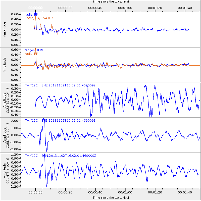
Signal To Noise
| Channel | StoN | STA | LTA |
| TA:Y12C: :BHZ:20131102T16:02:01.469009Z | 4.0002666 | 5.7927195E-7 | 1.4480834E-7 |
| TA:Y12C: :BHN:20131102T16:02:01.469009Z | 2.505159 | 2.687464E-7 | 1.0727718E-7 |
| TA:Y12C: :BHE:20131102T16:02:01.469009Z | 1.4580531 | 1.2630245E-7 | 8.662404E-8 |
| Arrivals |
| Ps | 6.3 SECOND |
| PpPs | 17 SECOND |
| PsPs/PpSs | 24 SECOND |


