You are here: Home > Network List > TA - USArray Transportable Network (new EarthScope stations) Stations List
> Station Y55A Saluda, SC, USA > Earthquake Result Viewer
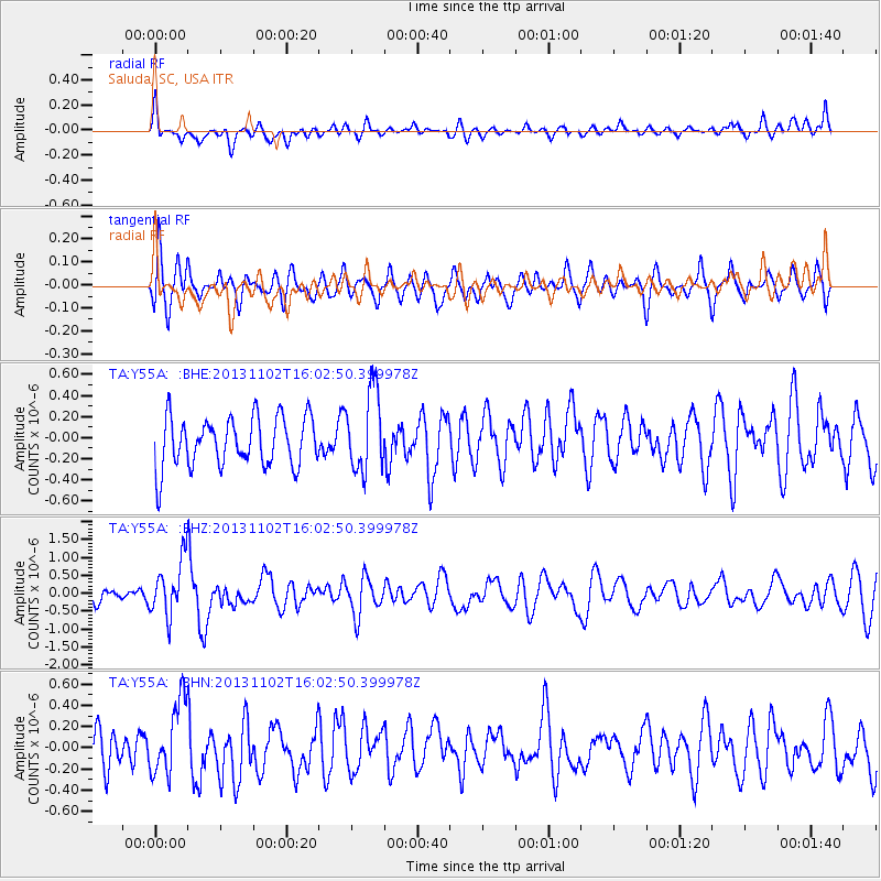
Y55A Saluda, SC, USA - Earthquake Result Viewer
*The percent match for this event was below the threshold and hence no stack was calculated.
| Earthquake location: |
Easter Island Region |
| Earthquake latitude/longitude: |
-23.6/-112.6 |
| Earthquake time(UTC): |
2013/11/02 (306) 15:52:46 GMT |
| Earthquake Depth: |
10 km |
| Earthquake Magnitude: |
6.0 MWW, 5.9 MWB, 6.0 MWW, 6.0 MWC, 6.1 MWC |
| Earthquake Catalog/Contributor: |
NEIC PDE/NEIC COMCAT |
|
| Network: |
TA USArray Transportable Network (new EarthScope stations) |
| Station: |
Y55A Saluda, SC, USA |
| Lat/Lon: |
33.94 N/81.86 W |
| Elevation: |
164 m |
|
| Distance: |
64.3 deg |
| Az: |
28.139 deg |
| Baz: |
211.348 deg |
| Ray Param: |
$rayparam |
*The percent match for this event was below the threshold and hence was not used in the summary stack. |
|
| Radial Match: |
49.912254 % |
| Radial Bump: |
400 |
| Transverse Match: |
57.82199 % |
| Transverse Bump: |
400 |
| SOD ConfigId: |
626651 |
| Insert Time: |
2014-04-19 10:11:15.908 +0000 |
| GWidth: |
2.5 |
| Max Bumps: |
400 |
| Tol: |
0.001 |
|
Signal To Noise
| Channel | StoN | STA | LTA |
| TA:Y55A: :BHZ:20131102T16:02:50.399978Z | 2.7288585 | 7.655882E-7 | 2.8055257E-7 |
| TA:Y55A: :BHN:20131102T16:02:50.399978Z | 1.6894717 | 3.4667644E-7 | 2.0519813E-7 |
| TA:Y55A: :BHE:20131102T16:02:50.399978Z | 1.6419894 | 3.831361E-7 | 2.3333654E-7 |
| Arrivals |
| Ps | |
| PpPs | |
| PsPs/PpSs | |


