You are here: Home > Network List > US - United States National Seismic Network Stations List
> Station AGMN Agassiz National Wildlife Refuge, Minnesota, USA > Earthquake Result Viewer
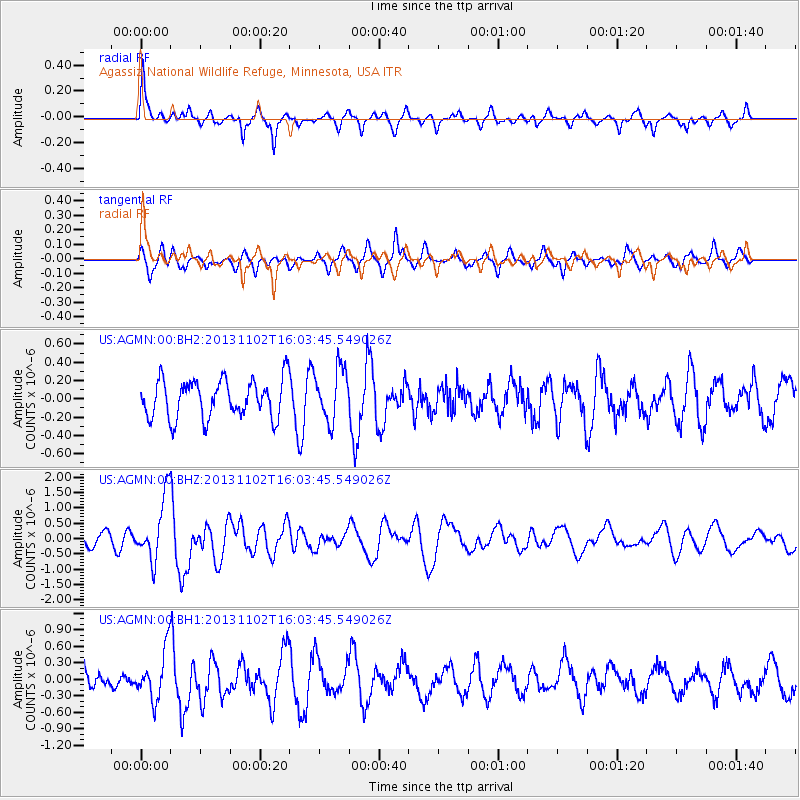
AGMN Agassiz National Wildlife Refuge, Minnesota, USA - Earthquake Result Viewer
*The percent match for this event was below the threshold and hence no stack was calculated.
| Earthquake location: |
Easter Island Region |
| Earthquake latitude/longitude: |
-23.6/-112.6 |
| Earthquake time(UTC): |
2013/11/02 (306) 15:52:46 GMT |
| Earthquake Depth: |
10 km |
| Earthquake Magnitude: |
6.0 MWW, 5.9 MWB, 6.0 MWW, 6.0 MWC, 6.1 MWC |
| Earthquake Catalog/Contributor: |
NEIC PDE/NEIC COMCAT |
|
| Network: |
US United States National Seismic Network |
| Station: |
AGMN Agassiz National Wildlife Refuge, Minnesota, USA |
| Lat/Lon: |
48.30 N/95.86 W |
| Elevation: |
351 m |
|
| Distance: |
73.2 deg |
| Az: |
11.588 deg |
| Baz: |
196.015 deg |
| Ray Param: |
$rayparam |
*The percent match for this event was below the threshold and hence was not used in the summary stack. |
|
| Radial Match: |
74.32125 % |
| Radial Bump: |
400 |
| Transverse Match: |
60.151897 % |
| Transverse Bump: |
368 |
| SOD ConfigId: |
626651 |
| Insert Time: |
2014-04-19 10:12:07.852 +0000 |
| GWidth: |
2.5 |
| Max Bumps: |
400 |
| Tol: |
0.001 |
|
Signal To Noise
| Channel | StoN | STA | LTA |
| US:AGMN:00:BHZ:20131102T16:03:45.549026Z | 4.92894 | 1.0348155E-6 | 2.0994686E-7 |
| US:AGMN:00:BH1:20131102T16:03:45.549026Z | 1.6456904 | 4.464117E-7 | 2.7126103E-7 |
| US:AGMN:00:BH2:20131102T16:03:45.549026Z | 1.3797033 | 2.8639585E-7 | 2.0757786E-7 |
| Arrivals |
| Ps | |
| PpPs | |
| PsPs/PpSs | |


