You are here: Home > Network List > US - United States National Seismic Network Stations List
> Station HAWA Hanford, Washington, USA > Earthquake Result Viewer
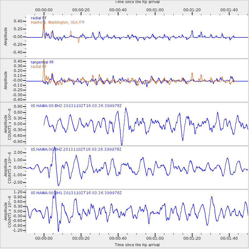
HAWA Hanford, Washington, USA - Earthquake Result Viewer
*The percent match for this event was below the threshold and hence no stack was calculated.
| Earthquake location: |
Easter Island Region |
| Earthquake latitude/longitude: |
-23.6/-112.6 |
| Earthquake time(UTC): |
2013/11/02 (306) 15:52:46 GMT |
| Earthquake Depth: |
10 km |
| Earthquake Magnitude: |
6.0 MWW, 5.9 MWB, 6.0 MWW, 6.0 MWC, 6.1 MWC |
| Earthquake Catalog/Contributor: |
NEIC PDE/NEIC COMCAT |
|
| Network: |
US United States National Seismic Network |
| Station: |
HAWA Hanford, Washington, USA |
| Lat/Lon: |
46.39 N/119.53 W |
| Elevation: |
364 m |
|
| Distance: |
70.0 deg |
| Az: |
354.895 deg |
| Baz: |
173.23 deg |
| Ray Param: |
$rayparam |
*The percent match for this event was below the threshold and hence was not used in the summary stack. |
|
| Radial Match: |
69.00059 % |
| Radial Bump: |
400 |
| Transverse Match: |
64.18672 % |
| Transverse Bump: |
400 |
| SOD ConfigId: |
626651 |
| Insert Time: |
2014-04-19 10:13:00.799 +0000 |
| GWidth: |
2.5 |
| Max Bumps: |
400 |
| Tol: |
0.001 |
|
Signal To Noise
| Channel | StoN | STA | LTA |
| US:HAWA:00:BHZ:20131102T16:03:26.399978Z | 2.2062254 | 5.947977E-7 | 2.695997E-7 |
| US:HAWA:00:BH1:20131102T16:03:26.399978Z | 2.0197253 | 3.7028522E-7 | 1.8333445E-7 |
| US:HAWA:00:BH2:20131102T16:03:26.399978Z | 1.1445819 | 2.5737458E-7 | 2.2486341E-7 |
| Arrivals |
| Ps | |
| PpPs | |
| PsPs/PpSs | |


