You are here: Home > Network List > US - United States National Seismic Network Stations List
> Station OGNE Ogallala, Nebraska, USA > Earthquake Result Viewer
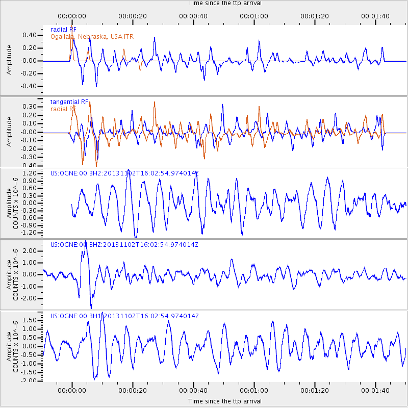
OGNE Ogallala, Nebraska, USA - Earthquake Result Viewer
*The percent match for this event was below the threshold and hence no stack was calculated.
| Earthquake location: |
Easter Island Region |
| Earthquake latitude/longitude: |
-23.6/-112.6 |
| Earthquake time(UTC): |
2013/11/02 (306) 15:52:46 GMT |
| Earthquake Depth: |
10 km |
| Earthquake Magnitude: |
6.0 MWW, 5.9 MWB, 6.0 MWW, 6.0 MWC, 6.1 MWC |
| Earthquake Catalog/Contributor: |
NEIC PDE/NEIC COMCAT |
|
| Network: |
US United States National Seismic Network |
| Station: |
OGNE Ogallala, Nebraska, USA |
| Lat/Lon: |
40.95 N/102.03 W |
| Elevation: |
0.0 m |
|
| Distance: |
65.0 deg |
| Az: |
8.814 deg |
| Baz: |
190.69 deg |
| Ray Param: |
$rayparam |
*The percent match for this event was below the threshold and hence was not used in the summary stack. |
|
| Radial Match: |
69.90987 % |
| Radial Bump: |
284 |
| Transverse Match: |
56.94788 % |
| Transverse Bump: |
326 |
| SOD ConfigId: |
626651 |
| Insert Time: |
2014-04-19 10:13:47.430 +0000 |
| GWidth: |
2.5 |
| Max Bumps: |
400 |
| Tol: |
0.001 |
|
Signal To Noise
| Channel | StoN | STA | LTA |
| US:OGNE:00:BHZ:20131102T16:02:54.974014Z | 6.26342 | 1.3628621E-6 | 2.1759072E-7 |
| US:OGNE:00:BH1:20131102T16:02:54.974014Z | 0.652273 | 4.3344897E-7 | 6.6452077E-7 |
| US:OGNE:00:BH2:20131102T16:02:54.974014Z | 0.8306841 | 5.341677E-7 | 6.430456E-7 |
| Arrivals |
| Ps | |
| PpPs | |
| PsPs/PpSs | |


