You are here: Home > Network List > 7A - Mid-Atlantic Geophysical Integrative Collaboration Stations List
> Station FOXP Brandywine, West Virginia USA > Earthquake Result Viewer
FOXP Brandywine, West Virginia USA - Earthquake Result Viewer
| Earthquake location: |
South Of Panama |
| Earthquake latitude/longitude: |
8.0/-82.7 |
| Earthquake time(UTC): |
2014/12/08 (342) 08:54:52 GMT |
| Earthquake Depth: |
20 km |
| Earthquake Magnitude: |
6.6 MWW, 6.3 MWB, 6.7 MI |
| Earthquake Catalog/Contributor: |
NEIC PDE/NEIC COMCAT |
|
| Network: |
7A Mid-Atlantic Geophysical Integrative Collaboration |
| Station: |
FOXP Brandywine, West Virginia USA |
| Lat/Lon: |
38.63 N/79.25 W |
| Elevation: |
485 m |
|
| Distance: |
30.7 deg |
| Az: |
5.298 deg |
| Baz: |
186.705 deg |
| Ray Param: |
0.07925587 |
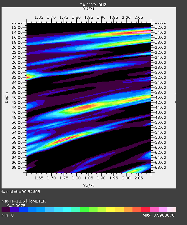
| Estimated Moho Depth: |
13.5 km |
| Estimated Crust Vp/Vs: |
2.10 |
| Assumed Crust Vp: |
6.159 km/s |
| Estimated Crust Vs: |
2.936 km/s |
| Estimated Crust Poisson's Ratio: |
0.35 |
|
| Radial Match: |
90.54695 % |
| Radial Bump: |
326 |
| Transverse Match: |
69.585075 % |
| Transverse Bump: |
400 |
| SOD ConfigId: |
3390531 |
| Insert Time: |
2019-04-15 10:37:13.202 +0000 |
| GWidth: |
2.5 |
| Max Bumps: |
400 |
| Tol: |
0.001 |
|

Signal To Noise
| Channel | StoN | STA | LTA |
| 7A:FOXP: :BHZ:20141208T09:00:35.435012Z | 4.7967744 | 1.6612628E-6 | 3.4632916E-7 |
| 7A:FOXP: :BHN:20141208T09:00:35.435012Z | 5.1141977 | 1.4341991E-6 | 2.8043482E-7 |
| 7A:FOXP: :BHE:20141208T09:00:35.435012Z | 1.0448972 | 2.464786E-7 | 2.358879E-7 |
| Arrivals |
| Ps | 2.6 SECOND |
| PpPs | 6.4 SECOND |
| PsPs/PpSs | 8.9 SECOND |


