You are here: Home > Network List > 7A - Mid-Atlantic Geophysical Integrative Collaboration Stations List
> Station RTSN Coon Bone Island, West Virginia USA > Earthquake Result Viewer
RTSN Coon Bone Island, West Virginia USA - Earthquake Result Viewer
| Earthquake location: |
South Of Panama |
| Earthquake latitude/longitude: |
8.0/-82.7 |
| Earthquake time(UTC): |
2014/12/08 (342) 08:54:52 GMT |
| Earthquake Depth: |
20 km |
| Earthquake Magnitude: |
6.6 MWW, 6.3 MWB, 6.7 MI |
| Earthquake Catalog/Contributor: |
NEIC PDE/NEIC COMCAT |
|
| Network: |
7A Mid-Atlantic Geophysical Integrative Collaboration |
| Station: |
RTSN Coon Bone Island, West Virginia USA |
| Lat/Lon: |
38.94 N/79.58 W |
| Elevation: |
949 m |
|
| Distance: |
31.0 deg |
| Az: |
4.721 deg |
| Baz: |
186.0 deg |
| Ray Param: |
0.07918087 |
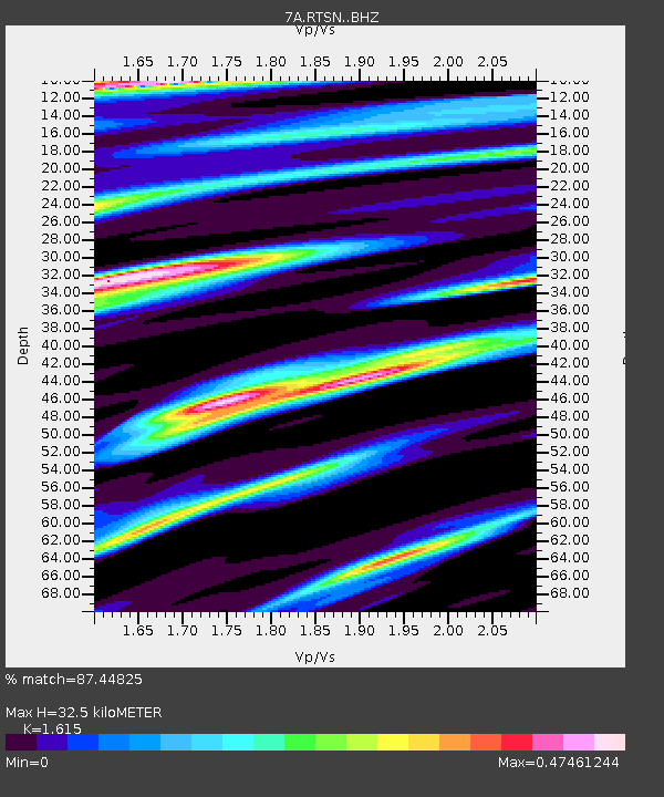
| Estimated Moho Depth: |
32.5 km |
| Estimated Crust Vp/Vs: |
1.62 |
| Assumed Crust Vp: |
6.159 km/s |
| Estimated Crust Vs: |
3.813 km/s |
| Estimated Crust Poisson's Ratio: |
0.19 |
|
| Radial Match: |
87.44825 % |
| Radial Bump: |
400 |
| Transverse Match: |
55.737522 % |
| Transverse Bump: |
400 |
| SOD ConfigId: |
3390531 |
| Insert Time: |
2019-04-15 10:37:20.805 +0000 |
| GWidth: |
2.5 |
| Max Bumps: |
400 |
| Tol: |
0.001 |
|

Signal To Noise
| Channel | StoN | STA | LTA |
| 7A:RTSN: :BHZ:20141208T09:00:37.965011Z | 6.4553165 | 2.0360221E-6 | 3.1540236E-7 |
| 7A:RTSN: :BHN:20141208T09:00:37.965011Z | 4.099354 | 1.3454446E-6 | 3.2820896E-7 |
| 7A:RTSN: :BHE:20141208T09:00:37.965011Z | 1.0300558 | 4.6342691E-7 | 4.499047E-7 |
| Arrivals |
| Ps | 3.5 SECOND |
| PpPs | 13 SECOND |
| PsPs/PpSs | 16 SECOND |


