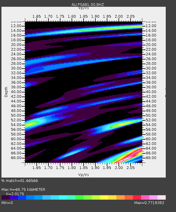
PSAB1 Pilbara Seismic Array Element B1 - Earthquake Result Viewer

Earthquake location: Tonga Islands Region
Earthquake latitude/longitude: -19.2/-172.6
Earthquake time(UTC): 2013/11/02 (306) 18:53:46 GMT
Earthquake Depth: 10 km
Earthquake Magnitude: 6.2 MWW, 6.2 MWB, 6.2 MWW, 6.3 MWC, 6.5 MI
Earthquake Catalog/Contributor: NEIC PDE/NEIC COMCAT
Network: AU Australian Seismological Centre
Station: PSAB1 Pilbara Seismic Array Element B1
Lat/Lon: 21.57 S/119.82 E
Elevation: 317 m
Distance: 62.9 deg
Az: 255.069 deg
Baz: 101.13 deg
Ray Param: 0.05992226
Estimated Moho Depth: 68.75 km
Estimated Crust Vp/Vs: 2.02
Assumed Crust Vp: 6.464 km/s
Estimated Crust Vs: 3.204 km/s
Estimated Crust Poisson's Ratio: 0.34
Radial Match: 81.66566 %
Radial Bump: 400
Transverse Match: 70.529884 %
Transverse Bump: 400
SOD ConfigId: 626651
Insert Time: 2014-04-19 10:24:48.650 +0000
GWidth: 2.5
Max Bumps: 400
Tol: 0.001

Signal To Noise

ChannelStoNSTALTA
AU:PSAB1:00:BHZ:20131102T19:03:42.043982Z3.41210449.245286E-72.7095555E-7
AU:PSAB1:00:BH1:20131102T19:03:42.043982Z3.68456485.3330723E-71.447409E-7
AU:PSAB1:00:BH2:20131102T19:03:42.043982Z1.20735452.3340928E-71.9332289E-7
Arrivals
Ps11 SECOND
PpPs31 SECOND
PsPs/PpSs42 SECOND