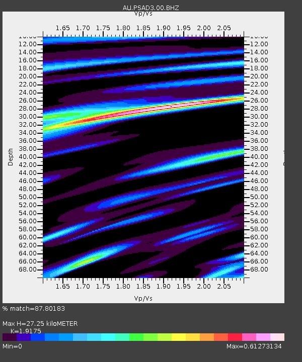
PSAD3 Pilbara Seismic Array Element D3 - Earthquake Result Viewer

Earthquake location: Tonga Islands Region
Earthquake latitude/longitude: -19.2/-172.6
Earthquake time(UTC): 2013/11/02 (306) 18:53:46 GMT
Earthquake Depth: 10 km
Earthquake Magnitude: 6.2 MWW, 6.2 MWB, 6.2 MWW, 6.3 MWC, 6.5 MI
Earthquake Catalog/Contributor: NEIC PDE/NEIC COMCAT
Network: AU Australian Seismological Centre
Station: PSAD3 Pilbara Seismic Array Element D3
Lat/Lon: 21.64 S/119.78 E
Elevation: 327 m
Distance: 62.9 deg
Az: 254.98 deg
Baz: 101.104 deg
Ray Param: 0.059906624
Estimated Moho Depth: 27.25 km
Estimated Crust Vp/Vs: 1.92
Assumed Crust Vp: 6.464 km/s
Estimated Crust Vs: 3.371 km/s
Estimated Crust Poisson's Ratio: 0.31
Radial Match: 87.80183 %
Radial Bump: 400
Transverse Match: 70.40489 %
Transverse Bump: 400
SOD ConfigId: 626651
Insert Time: 2014-04-19 10:25:04.338 +0000
GWidth: 2.5
Max Bumps: 400
Tol: 0.001

Signal To Noise

ChannelStoNSTALTA
AU:PSAD3:00:BHZ:20131102T19:03:42.194006Z3.96469121.0146368E-62.5591822E-7
AU:PSAD3:00:BH1:20131102T19:03:42.194006Z1.32769682.2848513E-71.7209135E-7
AU:PSAD3:00:BH2:20131102T19:03:42.194006Z2.72883344.0543856E-71.4857578E-7
Arrivals
Ps4.0 SECOND
PpPs12 SECOND
PsPs/PpSs16 SECOND